IMAGES TAKEN NEAR TO
Slaley, HEXHAM, NE47 0AF
Introduction
This page details the photographs taken nearby to NE47 0AF by members of the Geograph project.
The Geograph project started in 2005 with the aim of publishing, organising and preserving representative images for every square kilometre of Great Britain, Ireland and the Isle of Man.

There are currently over 7.5m images from over14,400 individuals and you can help contribute to the project by visiting https://www.geograph.org.uk
Image Map
Images are licensed for reuse under creativecommons.org/licenses/by-sa/2.0
Notes
- Clicking on the map will re-center to the selected point.
- The higher the marker number, the further away the image location is from the centre of the postcode.
Image Listing (12 Images Found)
Images are licensed for reuse under creativecommons.org/licenses/by-sa/2.0
Image
Details
Distance
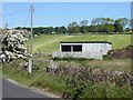
1
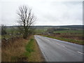
Strothers Bank (B6306)
Heading south towards Blanchland.
Image: © JThomas
Taken: 2 Apr 2016
0.05 miles
2
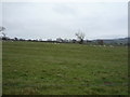
Grazing near Townhead Farm
East of Strothers Bank.
Image: © JThomas
Taken: 2 Apr 2016
0.08 miles
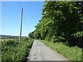
3
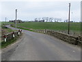
Strothers Bank Road
Looking north-westward in the direction of Slaley.
Image: © Peter Wood
Taken: 7 May 2016
0.11 miles
4
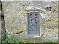
Ordnance Survey Flush Bracket G2993
This can be found on the track-side wall of a house - private dwelling - beside Strothers Bank Road.
For more detail see : http://www.bench-marks.org.uk/bm11081
Image: © Peter Wood
Taken: 7 May 2016
0.12 miles
6
Tarmac byway past Highclear
To the west of Slaley village.
Image: © Oliver Dixon
Taken: 31 May 2020
0.15 miles
7
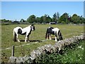
Two Shire horses
Near West Ridley Hall. The horse on the left is well-blinkerred.
Image: © Oliver Dixon
Taken: 31 May 2020
0.17 miles
8
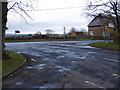
Junction at the west end of Slaley Village
Image: © Clive Nicholson
Taken: 23 Nov 2009
0.17 miles
10
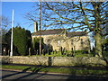
Slaley, St Mary's church
The present church of St Mary at Slaley was rebuilt in 1832, although there was a church mentioned here as early as 1239.
Image: © Les Hull
Taken: 11 Jan 2006
0.22 miles