IMAGES TAKEN NEAR TO
Colwell, HEXHAM, NE46 4TS
Introduction
This page details the photographs taken nearby to NE46 4TS by members of the Geograph project.
The Geograph project started in 2005 with the aim of publishing, organising and preserving representative images for every square kilometre of Great Britain, Ireland and the Isle of Man.

There are currently over 7.5m images from over14,400 individuals and you can help contribute to the project by visiting https://www.geograph.org.uk
Image Map
Images are licensed for reuse under creativecommons.org/licenses/by-sa/2.0
Notes
- Clicking on the map will re-center to the selected point.
- The higher the marker number, the further away the image location is from the centre of the postcode.
Image Listing (8 Images Found)
Images are licensed for reuse under creativecommons.org/licenses/by-sa/2.0
Image
Details
Distance

2
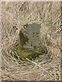
Old Milestone by the B6342, north east of Fell House, Chollerton Parish
Carved stone post by the B6342, in parish of CHOLLERTON (TYNEDALE District), Fell House, Little Swinburne, on grass verge, on North side of road. Rothbury stone, erected by the Alemouth & Hexham, western part turnpike trust in the 18th century.
Inscription reads:-
: R.B / 21 : : H / 10 :
(To Rothbury and Hexham)
Milestone Society National ID: NB_RBHX21.
Image: © IA Davison
Taken: 5 Feb 2004
0.13 miles
3
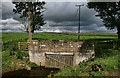
Thockrington Burn
The B6342 crossing Thockrington Burn near Fell House Farm.
Image: © Peter McDermott
Taken: 21 Aug 2011
0.16 miles

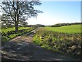
7
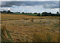
Fell House
Flattened crop of oats at Fell House Farm.
Image: © Peter McDermott
Taken: 21 Aug 2011
0.23 miles
