IMAGES TAKEN NEAR TO
Acomb, HEXHAM, NE46 4RW
Introduction
This page details the photographs taken nearby to NE46 4RW by members of the Geograph project.
The Geograph project started in 2005 with the aim of publishing, organising and preserving representative images for every square kilometre of Great Britain, Ireland and the Isle of Man.

There are currently over 7.5m images from over14,400 individuals and you can help contribute to the project by visiting https://www.geograph.org.uk
Image Map
Images are licensed for reuse under creativecommons.org/licenses/by-sa/2.0
Notes
- Clicking on the map will re-center to the selected point.
- The higher the marker number, the further away the image location is from the centre of the postcode.
Image Listing (21 Images Found)
Images are licensed for reuse under creativecommons.org/licenses/by-sa/2.0
Image
Details
Distance
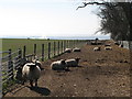
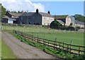
3

Salmons Well Farm
In a commanding position overlooking Tynedale.
Image: © Oliver Dixon
Taken: 9 Jul 2020
0.05 miles
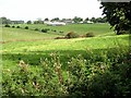
6
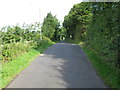
Passing place, north of New Rift Farm
Image: © Alex McGregor
Taken: 25 Aug 2010
0.12 miles
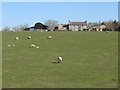
7
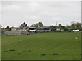
View towards Salmonswell Farm
Looking in a northerly direction across grass fields towards the barns and other buildings of Salmonswell Farm.
Image: © Graham Robson
Taken: 6 May 2017
0.17 miles
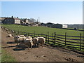
8
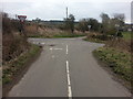
Crossroads east of Salmonswell Farm
Image: © Clive Nicholson
Taken: 15 Mar 2015
0.19 miles
9

Country road at Silver Hill
Tynedale in the distance.
Image: © Oliver Dixon
Taken: 7 Feb 2018
0.19 miles