IMAGES TAKEN NEAR TO
Acomb, HEXHAM, NE46 4RA
Introduction
This page details the photographs taken nearby to NE46 4RA by members of the Geograph project.
The Geograph project started in 2005 with the aim of publishing, organising and preserving representative images for every square kilometre of Great Britain, Ireland and the Isle of Man.

There are currently over 7.5m images from over14,400 individuals and you can help contribute to the project by visiting https://www.geograph.org.uk
Image Map
Images are licensed for reuse under creativecommons.org/licenses/by-sa/2.0
Notes
- Clicking on the map will re-center to the selected point.
- The higher the marker number, the further away the image location is from the centre of the postcode.
Image Listing (41 Images Found)
Images are licensed for reuse under creativecommons.org/licenses/by-sa/2.0
Image
Details
Distance
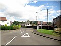
2

Garden House Drive
Housing estate on the south side of Acomb.
Image: © Oliver Dixon
Taken: 6 May 2020
0.08 miles
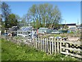
3

Allotment at Acomb
Along with a scarecrow.
Image: © Oliver Dixon
Taken: 6 May 2020
0.09 miles
5
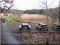
Acomb Minewater Treatment Scheme
It is hard to imagine now that the Northumberland Coalfield extended so far up into Tynedale, but coal was mined for some fifty years at this site in the early 20th century. The mine was closed in 1952 (long before the coal industry was decimated in the 1980s). An unfortunate legacy was pollution of the Red Burn caused by the overflow of heavily contaminated minewater. This treatment scheme was established in 2001 to deal with the problem. Filtering the water through the reedbeds in the background forms the final stage in the process http://www.coal.gov.uk/resources/environment/acombminewatertreatmentscheme.cfm . The area has been developed as a small recreational area with picnic benches, and the old railway which once served the mine forms an attractive path down to Waters Meet at the confluence of the South and North Tyne Rivers.
Image: © Oliver Dixon
Taken: 14 Jan 2008
0.10 miles
6
Allotments in Acomb
On Garden House Lane.
Image: © Oliver Dixon
Taken: 11 Sep 2008
0.11 miles
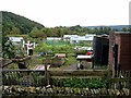
7

Field south of Acomb
The allotments are in the middle distance.
Image: © Oliver Dixon
Taken: 6 May 2020
0.12 miles
8
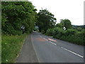
Leaving Acomb
A6079 heading south east towards the A69 and Hexham.
Image: © JThomas
Taken: 8 Aug 2015
0.12 miles
9
Acomb Minewater Treatment Scheme
It is hard to imagine now that the Northumberland Coalfield extended so far up into Tynedale, but coal was mined for some fifty years at this site in the early 20th century. The mine was closed in 1952 (long before the coal industry was decimated in the 1980s). An unfortunate legacy was pollution of the Red Burn caused by the overflow of heavily contaminated minewater. This treatment scheme was established in 2001 to deal with the problem. Filtering the water through the reedbeds in the background forms the final stage in the process http://www.coal.gov.uk/resources/environment/acombminewatertreatmentscheme.cfm .
Image: © Oliver Dixon
Taken: 14 Jan 2008
0.12 miles
10
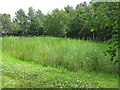
Reed bed no.1 at the (former) Acomb colliery (2)
See Image
Image: © Mike Quinn
Taken: 19 Jul 2020
0.12 miles