IMAGES TAKEN NEAR TO
Tynedale Terrace, HEXHAM, NE46 4QL
Introduction
This page details the photographs taken nearby to Tynedale Terrace, NE46 4QL by members of the Geograph project.
The Geograph project started in 2005 with the aim of publishing, organising and preserving representative images for every square kilometre of Great Britain, Ireland and the Isle of Man.

There are currently over 7.5m images from over14,400 individuals and you can help contribute to the project by visiting https://www.geograph.org.uk
Image Map
Images are licensed for reuse under creativecommons.org/licenses/by-sa/2.0
Notes
- Clicking on the map will re-center to the selected point.
- The higher the marker number, the further away the image location is from the centre of the postcode.
Image Listing (33 Images Found)
Images are licensed for reuse under creativecommons.org/licenses/by-sa/2.0
Image
Details
Distance
1
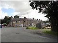
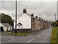
Tynedale Terrace, Acomb
The western end of the village is not as old as the eastern. I assume these houses are 19th century and probably built for the miners who worked in the local pit just down the road.
Image: © Robert Graham
Taken: 19 Sep 2012
0.00 miles
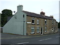
3

Morrison Terrace, Acomb
This terrace leads into Acomb village from the A6079
Image: © Brian Norman
Taken: 7 Oct 2006
0.02 miles
4
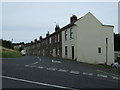
Morrison Terrace, Acomb
A local told me they used to be housing for mineworkers.
Image: © JThomas
Taken: 8 Aug 2015
0.03 miles
8
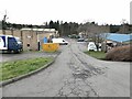
Acomb Industrial Estate
A small industrial estate on the site of the Acomb Colliery (closed 1952).
Image: © Oliver Dixon
Taken: 19 Mar 2023
0.08 miles
9
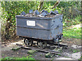
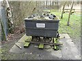
Pit tub at the (former) Acomb colliery
The plaque on the tub says that it was originally placed at the entrance to the site of the colliery but was relocated to its current position following the creation of a public space and wetland which forms part of a mine water treatment scheme for the Red Burn. The colliery, which started in 1909, employed 290 men at its peak and produced over 70,000 tons of coal a year; it closed in 1952.
Image: © Mike Quinn
Taken: 19 Jul 2020
0.09 miles
10
Pit tub, former Acomb Colliery
This pit tub commemorates the former Acomb Colliery which operated until 1952. The site was taken over and restored by Northumberland County Council in 1980.
Image: © Oliver Dixon
Taken: 19 Mar 2023
0.09 miles