IMAGES TAKEN NEAR TO
Wall, HEXHAM, NE46 4EX
Introduction
This page details the photographs taken nearby to NE46 4EX by members of the Geograph project.
The Geograph project started in 2005 with the aim of publishing, organising and preserving representative images for every square kilometre of Great Britain, Ireland and the Isle of Man.

There are currently over 7.5m images from over14,400 individuals and you can help contribute to the project by visiting https://www.geograph.org.uk
Image Map
Images are licensed for reuse under creativecommons.org/licenses/by-sa/2.0
Notes
- Clicking on the map will re-center to the selected point.
- The higher the marker number, the further away the image location is from the centre of the postcode.
Image Listing (76 Images Found)
Images are licensed for reuse under creativecommons.org/licenses/by-sa/2.0
Image
Details
Distance
1
Toll House, Brunton Bank
"Toll House" on the North side of the B6318. Originally serving the Newcastle-upon-Tyne to Carlisle Turnpike Trust.
Milestone Society National ID: NB.WAL
Image: © Phil Robertson
Taken: 10 Mar 2023
0.00 miles
4
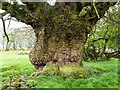
A warty tree
A warty tree - reputed to be over 1000 years old, adjacent to Hadrian's Wall National Trail.
Image: © Oliver Dixon
Taken: 30 Apr 2012
0.05 miles
5

Large tree with strange growths on its trunk near Hill Head Farm
This is the tree in the foreground of Image
Image: © Mike Quinn
Taken: 17 Mar 2009
0.05 miles
6
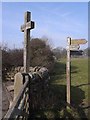
St Oswald's Cross, Heavenfield
A cross (not the original) erected at the site of the Battle of Heavenfield AD634. The inscription beneath reads "Heavenfield, where King Oswald, being about to engage in battle, erected the sign of the Holy Cross and on his knees, prayed to God and obtained the victory that his faith deserved." To the right is the signpost marking the end of St Oswald's Way http://www.stoswaldsway.com/home.html, a 156 Km long trail which starts at Holy Island on the Northumberland coast. At this end, the St Oswald's Way coincides for some kilometres with Hadrian's Wall National Trail.
Image: © Oliver Dixon
Taken: 18 Mar 2009
0.06 miles
7
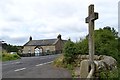
Cottage and cross at Heavenfield on the B6138
Image: © Neil Theasby
Taken: 26 Aug 2012
0.06 miles
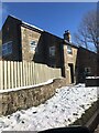
10
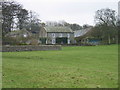
Planetrees Farm
Keys to the Past Web Site: These are the remains of an 18th or 19th century building housing a gingang. It has six sides, rather than being built in the more usual circular shape.
Image: © Les Hull
Taken: 19 Jan 2005
0.06 miles