IMAGES TAKEN NEAR TO
Wall, HEXHAM, NE46 4EG
Introduction
This page details the photographs taken nearby to NE46 4EG by members of the Geograph project.
The Geograph project started in 2005 with the aim of publishing, organising and preserving representative images for every square kilometre of Great Britain, Ireland and the Isle of Man.

There are currently over 7.5m images from over14,400 individuals and you can help contribute to the project by visiting https://www.geograph.org.uk
Image Map
Images are licensed for reuse under creativecommons.org/licenses/by-sa/2.0
Notes
- Clicking on the map will re-center to the selected point.
- The higher the marker number, the further away the image location is from the centre of the postcode.
Image Listing (17 Images Found)
Images are licensed for reuse under creativecommons.org/licenses/by-sa/2.0
Image
Details
Distance

4
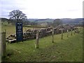
Roman Wall at Planetrees
In 1801 William Hutton witnessed part of Hadrian's Wall being dismantled to provide stone for the building of Planetrees Farmhouse.
Image: © Richard Young
Taken: 1 Jan 2006
0.20 miles
5
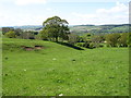
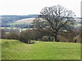
Descending to the North Tyne valley
Seen from the Hadrian's Wall Path, which is just off to the right of this shot.
Image: © David Purchase
Taken: 26 May 2013
0.21 miles
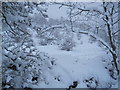
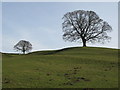
8
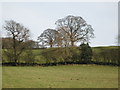
The Vallum west of Planetrees
The distinctive ditch and mounds of the Vallum can be seen beyond and to the right of the large tree in the centre of the photo.
Image: © Mike Quinn
Taken: 17 Mar 2009
0.21 miles