IMAGES TAKEN NEAR TO
Wall, HEXHAM, NE46 4EF
Introduction
This page details the photographs taken nearby to NE46 4EF by members of the Geograph project.
The Geograph project started in 2005 with the aim of publishing, organising and preserving representative images for every square kilometre of Great Britain, Ireland and the Isle of Man.

There are currently over 7.5m images from over14,400 individuals and you can help contribute to the project by visiting https://www.geograph.org.uk
Image Map
Images are licensed for reuse under creativecommons.org/licenses/by-sa/2.0
Notes
- Clicking on the map will re-center to the selected point.
- The higher the marker number, the further away the image location is from the centre of the postcode.
Image Listing (50 Images Found)
Images are licensed for reuse under creativecommons.org/licenses/by-sa/2.0
Image
Details
Distance
1

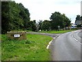
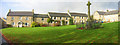
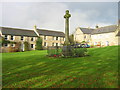
Village green at Wall
The A6079 to the right.
Image: © Oliver Dixon
Taken: 20 May 2020
0.04 miles
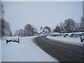
2
Entering Wall village from the north
On the A6079. The village of Wall is appropriately named as it lies close to Hadrian's Wall.
Image: © Oliver Dixon
Taken: 11 Sep 2008
0.06 miles
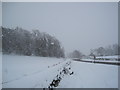
6
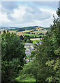
Buildings in Wall through gap in trees
The trees are on steeply rising ground to the east of the village; a public footpath climbs through the gap.
Image: © Trevor Littlewood
Taken: 16 Jul 2023
0.09 miles
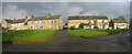
9
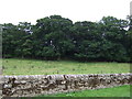
Wall near Wall
Stone wall and grazing north of the village, off the A6079.
Image: © JThomas
Taken: 8 Aug 2015
0.10 miles
10
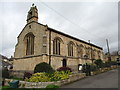
St George's church
Wall's parish church dates from 1895 and is unusual in that it is orientated S-N instead of W-E.
Image: © Gordon Hatton
Taken: 15 Aug 2018
0.10 miles