IMAGES TAKEN NEAR TO
Wall, HEXHAM, NE46 4DR
Introduction
This page details the photographs taken nearby to NE46 4DR by members of the Geograph project.
The Geograph project started in 2005 with the aim of publishing, organising and preserving representative images for every square kilometre of Great Britain, Ireland and the Isle of Man.

There are currently over 7.5m images from over14,400 individuals and you can help contribute to the project by visiting https://www.geograph.org.uk
Image Map
Images are licensed for reuse under creativecommons.org/licenses/by-sa/2.0
Notes
- Clicking on the map will re-center to the selected point.
- The higher the marker number, the further away the image location is from the centre of the postcode.
Image Listing (6 Images Found)
Images are licensed for reuse under creativecommons.org/licenses/by-sa/2.0
Image
Details
Distance
1
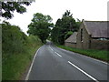
Front Street (A6079) passing Low Barns
Heading south east towards Hexham.
Image: © JThomas
Taken: 8 Aug 2015
0.02 miles
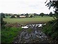
3

Cross Bank heading south-southeast
Cross Bank, the A6079, between the villages of Wall and Acomb, both of which it passes at their western edges.
Image: © Trevor Littlewood
Taken: 16 Jul 2023
0.15 miles
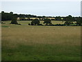
4
Field near Low Barns
Seen from the A6079 road between Wall and Acomb.
Image: © Oliver Dixon
Taken: 11 Sep 2008
0.17 miles

6
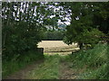
Farm track into field
Off Front Street (A6079)
Harvesting was in progress.
Image: © JThomas
Taken: 8 Aug 2015
0.21 miles