IMAGES TAKEN NEAR TO
Hallstile Cottages, HEXHAM, NE46 3PH
Introduction
This page details the photographs taken nearby to Hallstile Cottages, NE46 3PH by members of the Geograph project.
The Geograph project started in 2005 with the aim of publishing, organising and preserving representative images for every square kilometre of Great Britain, Ireland and the Isle of Man.

There are currently over 7.5m images from over14,400 individuals and you can help contribute to the project by visiting https://www.geograph.org.uk
Image Map
Images are licensed for reuse under creativecommons.org/licenses/by-sa/2.0
Notes
- Clicking on the map will re-center to the selected point.
- The higher the marker number, the further away the image location is from the centre of the postcode.
Image Listing (1528 Images Found)
Images are licensed for reuse under creativecommons.org/licenses/by-sa/2.0
Image
Details
Distance
1
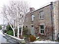
Henry King Memorial Almshouses, Hallstile Bank, Hexham
Image: © Andrew Curtis
Taken: 21 Mar 2018
0.00 miles
2
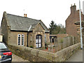
The former house of John Robson, Alemouth Road
John Robson and others founded the English Arboricultural Society (now the Royal Forestry Society) - see Image
Image: © Mike Quinn
Taken: 23 Jun 2009
0.01 miles
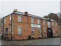
3
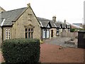
Henry King almshouses, Hexham (1)
Built in memory of Henry King who died in 1891 (the date "c.1391" in the Historic England listing is surely a misprint!) Listed Grade II (list entry 1370790).
Image: © Stephen Craven
Taken: 14 Mar 2020
0.01 miles
4
Henry King almshouses, Hexham (2)
Built in memory of Henry King who died in 1891 (the date "c.1391" in the Historic England listing is surely a misprint!) Listed Grade II (list entry 1370790).
The entrance arch (left) is more highly listed at grade II* (list entry 1042557), which explains that this late C17 or early C18 structure was relocated "from elsewhere".
Image: © Stephen Craven
Taken: 14 Mar 2020
0.01 miles
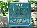
5
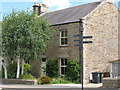
Number two, Alemouth Road, Hexham
The plaque in the garden commemorates the foundation of the English Arboricultural Society (now the Royal Forestry Society) at these premises on 10 January 1882.
Image: © Oliver Dixon
Taken: 9 Jan 2011
0.01 miles
6
Plaque at the former house of John Robson, Alemouth Road
See Image
Image: © Mike Quinn
Taken: 23 Jun 2009
0.02 miles
7
The lower end of Hallstile Bank (2)
This is the west side; a view of the east side (taken looking down the hill) is shown in Image
Image: © Mike Quinn
Taken: 10 Apr 2014
0.02 miles
9
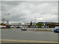
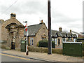
Roundabout at the bottom of Hallstile Bank, Hexham
Haugh Lane to the left, Alemouth Road to the right, and the Tesco car park straight ahead.
Image: © Stephen Craven
Taken: 14 Mar 2020
0.02 miles
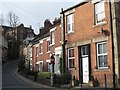
10
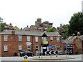
Haugh Lane in Hexham
Looking up to the town centre on the hill. The medieval Moot Hall is on the skyline.
Image: © Robert Graham
Taken: 11 Jul 2022
0.02 miles