IMAGES TAKEN NEAR TO
West End, West Road, HEXHAM, NE46 3JU
Introduction
This page details the photographs taken nearby to West End, West Road, NE46 3JU by members of the Geograph project.
The Geograph project started in 2005 with the aim of publishing, organising and preserving representative images for every square kilometre of Great Britain, Ireland and the Isle of Man.

There are currently over 7.5m images from over14,400 individuals and you can help contribute to the project by visiting https://www.geograph.org.uk
Image Map
Images are licensed for reuse under creativecommons.org/licenses/by-sa/2.0
Notes
- Clicking on the map will re-center to the selected point.
- The higher the marker number, the further away the image location is from the centre of the postcode.
Image Listing (123 Images Found)
Images are licensed for reuse under creativecommons.org/licenses/by-sa/2.0
Image
Details
Distance
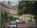
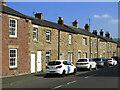
1
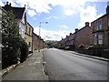
Terraced houses on West Road, Hexham
This is the B6531, the main route into the town from the west, from the A69.
Image: © Robert Graham
Taken: 19 Sep 2012
0.02 miles
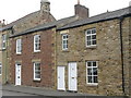
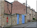
2
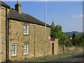
1, Quatre Bras
Quatre Bras was an early 19th C hamlet; no.1 is Grade II listed https://historicengland.org.uk/listing/the-list/list-entry/1042517?section=official-list-entry .
Image: © Mike Quinn
Taken: 31 May 2024
0.03 miles
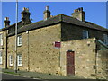
7
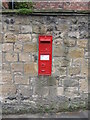
Victorian postbox, Glen Terrace
The location of this postbox is shown in Image
Image: © Mike Quinn
Taken: 12 May 2008
0.06 miles
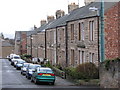
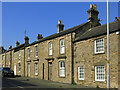
10
(Part of) Glen Terrace
Shows the location of Image
Image: © Mike Quinn
Taken: 12 May 2008
0.07 miles