IMAGES TAKEN NEAR TO
The Link, HEXHAM, NE46 3AN
Introduction
This page details the photographs taken nearby to The Link, NE46 3AN by members of the Geograph project.
The Geograph project started in 2005 with the aim of publishing, organising and preserving representative images for every square kilometre of Great Britain, Ireland and the Isle of Man.

There are currently over 7.5m images from over14,400 individuals and you can help contribute to the project by visiting https://www.geograph.org.uk
Image Map
Images are licensed for reuse under creativecommons.org/licenses/by-sa/2.0
Notes
- Clicking on the map will re-center to the selected point.
- The higher the marker number, the further away the image location is from the centre of the postcode.
Image Listing (43 Images Found)
Images are licensed for reuse under creativecommons.org/licenses/by-sa/2.0
Image
Details
Distance
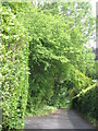
3
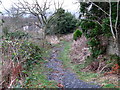
Shaw's "Lane"
The lane deteriorates into a footpath from here north to West Road.
Image: © Mike Quinn
Taken: 6 Dec 2007
0.08 miles
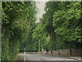
4
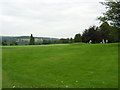
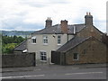
Grassed area on south side of B6531
The B6531 to the west of Hexham town centre passing an open area of manicured grass with trees, above which is a private housing estate.
Image: © Trevor Littlewood
Taken: 15 Aug 2019
0.09 miles
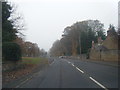
10
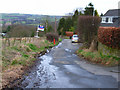
Shaws Lane, Hexham
An old lane bounding the western edge of the built-up area of Hexham
Image: © Oliver Dixon
Taken: 31 Mar 2006
0.12 miles