IMAGES TAKEN NEAR TO
HEXHAM, NE46 2PU
Introduction
This page details the photographs taken nearby to NE46 2PU by members of the Geograph project.
The Geograph project started in 2005 with the aim of publishing, organising and preserving representative images for every square kilometre of Great Britain, Ireland and the Isle of Man.

There are currently over 7.5m images from over14,400 individuals and you can help contribute to the project by visiting https://www.geograph.org.uk
Image Map
Images are licensed for reuse under creativecommons.org/licenses/by-sa/2.0
Notes
- Clicking on the map will re-center to the selected point.
- The higher the marker number, the further away the image location is from the centre of the postcode.
Image Listing (30 Images Found)
Images are licensed for reuse under creativecommons.org/licenses/by-sa/2.0
Image
Details
Distance
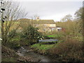
2
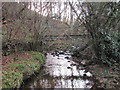
Ford at Coastley Burnfoot Farm
Over the Darden or Coastley Burn. Fortunately there is a footbridge alternative.
Image: © Oliver Dixon
Taken: 28 Nov 2011
0.01 miles
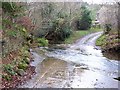
4
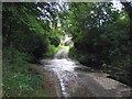
Bridge End Ford
This concrete bottomed ford on the Darden Burn is found just off the A69 close to Coastley Burnfoot Farm
Image: © John Walton
Taken: 3 May 2014
0.03 miles
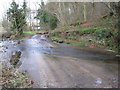
6
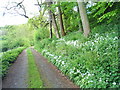
Bridleway/farm track near Burnfoot in the South Tyne Valley
Picture taken on the bridleway between Greenshaw Plain and Warden, near Hexham, Northumberland.
There is a 360° panorama of this location at http://www.jaydax.co.uk/showcase/panorama/southtynevalley/
Image: © John Chapman
Taken: 22 May 2009
0.03 miles
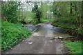
8
Flood defences for the River South Tyne near Bridge End
Image: © Mike Quinn
Taken: 4 Oct 2010
0.14 miles
9
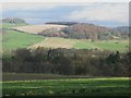
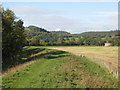
Pastures and woodland east of Coastley (2)
Looking across the Tyne Valley towards Private-walk Wood in Image near High Warden. The A69 and the River Tyne are hidden in the valley below; it is just possible to see the route of the Newcastle to Carlisle railway through the bare branches.
Image: © Mike Quinn
Taken: 7 Nov 2009
0.14 miles
10
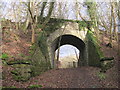
Old Railway Bridge, Hexham to Allendale Line
Image: © Les Hull
Taken: 7 Jan 2015
0.16 miles