IMAGES TAKEN NEAR TO
Dipton Mill Road, HEXHAM, NE46 2JT
Introduction
This page details the photographs taken nearby to Dipton Mill Road, NE46 2JT by members of the Geograph project.
The Geograph project started in 2005 with the aim of publishing, organising and preserving representative images for every square kilometre of Great Britain, Ireland and the Isle of Man.

There are currently over 7.5m images from over14,400 individuals and you can help contribute to the project by visiting https://www.geograph.org.uk
Image Map
Images are licensed for reuse under creativecommons.org/licenses/by-sa/2.0
Notes
- Clicking on the map will re-center to the selected point.
- The higher the marker number, the further away the image location is from the centre of the postcode.
Image Listing (6 Images Found)
Images are licensed for reuse under creativecommons.org/licenses/by-sa/2.0
Image
Details
Distance
1
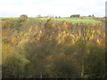
The wooded valley of West Dipton Burn
Looking north from the lane west of Dipton Mill in Image across the valley towards Image (photo by Oliver Dixon).
Image: © Mike Quinn
Taken: 3 Nov 2010
0.18 miles

4
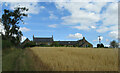
West Peterel Field
Farm south east of Hexham Racecourse
Image: © Brian Norman
Taken: 27 Jul 2022
0.21 miles
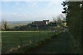
5
West Peterel Field Farm
Farm above the valley of the West Dipton Burn.
Image: © Oliver Dixon
Taken: 11 Feb 2010
0.21 miles
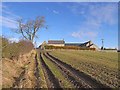
6
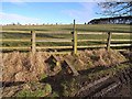
Stile at West Peterel Field
A very inadequate stile with some essential components missing.
Image: © Oliver Dixon
Taken: 11 Feb 2010
0.23 miles