IMAGES TAKEN NEAR TO
St. Nicholas Road, HEXHAM, NE46 2EZ
Introduction
This page details the photographs taken nearby to St. Nicholas Road, NE46 2EZ by members of the Geograph project.
The Geograph project started in 2005 with the aim of publishing, organising and preserving representative images for every square kilometre of Great Britain, Ireland and the Isle of Man.

There are currently over 7.5m images from over14,400 individuals and you can help contribute to the project by visiting https://www.geograph.org.uk
Image Map
Images are licensed for reuse under creativecommons.org/licenses/by-sa/2.0
Notes
- Clicking on the map will re-center to the selected point.
- The higher the marker number, the further away the image location is from the centre of the postcode.
Image Listing (558 Images Found)
Images are licensed for reuse under creativecommons.org/licenses/by-sa/2.0
Image
Details
Distance
1
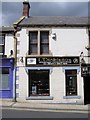
L Dickinson, Hexham
This is an optometrist's shop.
Image: © Kenneth Allen
Taken: 14 Jun 2006
0.02 miles
3
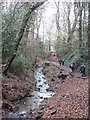
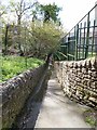
Valley of the Halgut Burn
Sometimes known as the Wydon Burn, this narrow wooded valley divides the Wydon Park estate (to the left) from the Elvaston Road estate.
Image: © Oliver Dixon
Taken: 19 Dec 2012
0.03 miles
6

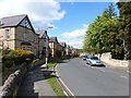
St Hilda's Road
One of the streets of Edwardian terrace houses off Elvaston Road to the south of Hexham town centre.
Image: © Oliver Dixon
Taken: 17 Apr 2012
0.04 miles
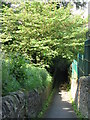
7
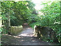
Passageway from Gaprigg Lane to Priestlands Lane
Many of the estates in Hexham are built up the steep hillside to the south of the town centre. The only link between the Elvaston estate and the Hextol estate (except via the main road at the bottom) is via this passageway across the valley of the Wydon Burn.
Image: © Oliver Dixon
Taken: 28 Apr 2012
0.04 miles
8
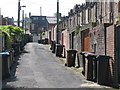
Rubbish bins
Between Elvaston Road and St Andrew's Road.
Image: © Mike Quinn
Taken: 5 Jun 2008
0.04 miles
9
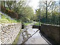
Passageway from Gaprigg Lane to Priestlands Lane
Many of the estates in Hexham are built up the steep hillside to the south of the town centre. The only link between the Elvaston estate and the Hextol estate (except via the main road at the bottom) is via this passageway across the valley of the Wydon Burn. To the right, the path leads to Priestlands Lane, straight ahead to Priestlands Crescent.
Image: © Oliver Dixon
Taken: 28 Apr 2012
0.05 miles
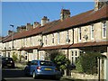
10
Lower end of Elvaston Road
Edwardian terraced housing.
Image: © Oliver Dixon
Taken: 28 Apr 2012
0.05 miles