IMAGES TAKEN NEAR TO
Valebrook, HEXHAM, NE46 2BN
Introduction
This page details the photographs taken nearby to Valebrook, NE46 2BN by members of the Geograph project.
The Geograph project started in 2005 with the aim of publishing, organising and preserving representative images for every square kilometre of Great Britain, Ireland and the Isle of Man.

There are currently over 7.5m images from over14,400 individuals and you can help contribute to the project by visiting https://www.geograph.org.uk
Image Map
Images are licensed for reuse under creativecommons.org/licenses/by-sa/2.0
Notes
- Clicking on the map will re-center to the selected point.
- The higher the marker number, the further away the image location is from the centre of the postcode.
Image Listing (75 Images Found)
Images are licensed for reuse under creativecommons.org/licenses/by-sa/2.0
Image
Details
Distance
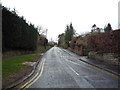
2
Causey Hill Road
Looking north showing position of Postbox No. NE46 65.
See Image] for postbox.
Image: © JThomas
Taken: 2 Apr 2016
0.15 miles
3
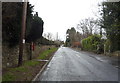
Causey Hill Road
Looking south showing position of Postbox No. NE46 65.
See Image] for postbox.
Image: © JThomas
Taken: 2 Apr 2016
0.15 miles
4
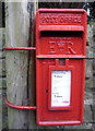
Close up, Elizabeth II postbox on Causey Hill Road
Postbox No. NE46 65.
See Image] for postbox.
Image: © JThomas
Taken: 2 Apr 2016
0.15 miles
5
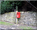
Elizabeth II postbox on Causey Hill Road
Image: © JThomas
Taken: 2 Apr 2016
0.15 miles
7
Wydon Park
Late 20th century housing estate on the steep hillside to the south-west of Hexham town centre.
Image: © Oliver Dixon
Taken: 25 Apr 2012
0.18 miles

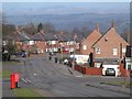
9
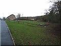
Wydon Park, Hexham
Housing estate on the steep, southern slopes of Hexham. A children's play area in the foreground. In the valley to the right is an old reservoir, which is currently being reclaimed and converted into a public park.
Image: © Oliver Dixon
Taken: 27 Dec 2007
0.20 miles
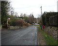
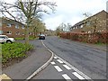
10
Whetstone Green
The road in the foreground is a bridge over the Cockshaw Burn.
Image: © Mike Quinn
Taken: 15 Jul 2010
0.21 miles