IMAGES TAKEN NEAR TO
Tyne Mills, HEXHAM, NE46 1XT
Introduction
This page details the photographs taken nearby to Tyne Mills, NE46 1XT by members of the Geograph project.
The Geograph project started in 2005 with the aim of publishing, organising and preserving representative images for every square kilometre of Great Britain, Ireland and the Isle of Man.

There are currently over 7.5m images from over14,400 individuals and you can help contribute to the project by visiting https://www.geograph.org.uk
Image Map
Images are licensed for reuse under creativecommons.org/licenses/by-sa/2.0
Notes
- Clicking on the map will re-center to the selected point.
- The higher the marker number, the further away the image location is from the centre of the postcode.
Image Listing (324 Images Found)
Images are licensed for reuse under creativecommons.org/licenses/by-sa/2.0
Image
Details
Distance
1
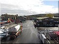
Carrs Billington, Hexham
A number of services to rural businesses and local residents are provided from the large Carrs Billington site in the town. They include agricultural supplies, fuel, and the retailing of several brands of agricultural machinery including Massey Ferguson.
Image: © Graham Robson
Taken: 2 May 2016
0.02 miles
2
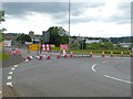
Closure of Hexham Railway Bridge
For a period of six weeks the main way into Hexham from the A69 is currently closed whilst the bridge over the railway is re-waterproofed. Access to the town from the main road is now via the Western Road, or via Riding Mill and Corbridge Road. Travelling by motor vehicle from the town to the many commercial premises on the north side of the railway involves a long detour, although the bridge is still open to pedestrians. The tower of Hexham Abbey Church Image can be seen in the middle distance.
Image: © Oliver Dixon
Taken: 21 Jun 2016
0.03 miles
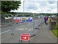
3
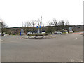
Roundabout on Alemouth Road, Hexham
Side roads either side of the main road serve industrial estates.
Image: © Stephen Craven
Taken: 14 Mar 2020
0.03 miles
4
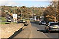
Roundabout ahead
The way out of Hexham on a sunny autumn day
Image: © roger geach
Taken: 1 Nov 2011
0.04 miles
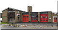
6
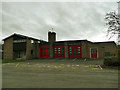
Hexham fire station
On an industrial estate north of the railway station.
Image: © Stephen Craven
Taken: 14 Mar 2020
0.04 miles
7
Closure of Hexham Railway Bridge
For a period of six weeks the main way into Hexham from the A69 is currently closed whilst the bridge over the railway is re-waterproofed. Access to the town from the main road is now via the Western Road, or via Riding Mill and Corbridge Road. Travelling by motor vehicle from the town to the many commercial premises on the north side of the railway involves a long detour, although the bridge is still open to pedestrians and cyclists.
Image: © Oliver Dixon
Taken: 21 Jun 2016
0.05 miles
8
Pedestrian underpass of the A6079 at the south end of Tyne Bridge (east side)
See Image
Image: © Mike Quinn
Taken: 26 Mar 2009
0.06 miles
9
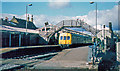
Hexham station, 1981
View eastward, towards Newcastle on the ex-NER Newcastle - Carlisle main line. Westbound is a 'boring' DMU, seemingly a two-car Metro-Cammell one.
Image: © Walter Dendy, deceased
Taken: 20 Oct 1981
0.06 miles
10
Closure of Hexham Railway Bridge
For a period of six weeks the main way into Hexham from the A69 is currently closed whilst the bridge over the railway is re-waterproofed. Access to the town from the main road is now via the Western Road, or via Riding Mill and Corbridge Road. Travelling by motor vehicle from the town to the many commercial premises on the north side of the railway involves a long detour, although the bridge is still open to pedestrians. This view shows how the road surface has been stripped off.
Image: © Oliver Dixon
Taken: 21 Jun 2016
0.06 miles