IMAGES TAKEN NEAR TO
HEXHAM, NE46 1SD
Introduction
This page details the photographs taken nearby to NE46 1SD by members of the Geograph project.
The Geograph project started in 2005 with the aim of publishing, organising and preserving representative images for every square kilometre of Great Britain, Ireland and the Isle of Man.

There are currently over 7.5m images from over14,400 individuals and you can help contribute to the project by visiting https://www.geograph.org.uk
Image Map
Images are licensed for reuse under creativecommons.org/licenses/by-sa/2.0
Notes
- Clicking on the map will re-center to the selected point.
- The higher the marker number, the further away the image location is from the centre of the postcode.
Image Listing (32 Images Found)
Images are licensed for reuse under creativecommons.org/licenses/by-sa/2.0
Image
Details
Distance
1
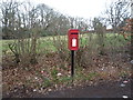
Elizabeth II postbox on Linnels Bank
Postbox No. NE46 96.
See Image] for close up.
Image: © JThomas
Taken: 2 Apr 2016
0.04 miles
2
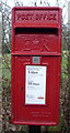
Close up, Elizabeth II postbox on Linnels Bank
Postbox No. NE46 96.
See Image] for wider view.
Image: © JThomas
Taken: 2 Apr 2016
0.04 miles
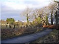
3

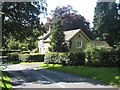
A stroll in winter sunshine
At Linnels in Hexhamshire.
Image: © Joan Sykes
Taken: 25 Jan 2009
0.05 miles
7
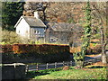
House near Linnels Bridge
An alternate view of the house in Image The wing towards the camera appears to be a barn conversion.
Image: © Oliver Dixon
Taken: 24 Aug 2008
0.12 miles
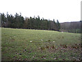
9
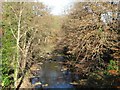
Devil's Water downstream from Linnels Bridge
Image: © Mike Quinn
Taken: 6 Nov 2007
0.15 miles
10
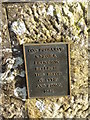
Plaque on Linnels Bridge
This plaque is a facsimile of the stone inscription on the ancient Linnels Bridge. It can be roughly translated as:
God preserve
Wmfoira (?)
Errington
built
this bridge
of lime
and stone
1581
No idea what Wmfoira means. Errington is a local family name. The date 1581 refers to the original bridge not the present structure dated 1698.
Image: © Oliver Dixon
Taken: 2 Feb 2018
0.15 miles