IMAGES TAKEN NEAR TO
Priestpopple, HEXHAM, NE46 1PE
Introduction
This page details the photographs taken nearby to Priestpopple, NE46 1PE by members of the Geograph project.
The Geograph project started in 2005 with the aim of publishing, organising and preserving representative images for every square kilometre of Great Britain, Ireland and the Isle of Man.

There are currently over 7.5m images from over14,400 individuals and you can help contribute to the project by visiting https://www.geograph.org.uk
Image Map
Images are licensed for reuse under creativecommons.org/licenses/by-sa/2.0
Notes
- Clicking on the map will re-center to the selected point.
- The higher the marker number, the further away the image location is from the centre of the postcode.
Image Listing (1480 Images Found)
Images are licensed for reuse under creativecommons.org/licenses/by-sa/2.0
Image
Details
Distance
2
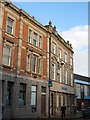
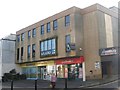
Hexham : Lloyd's Bank, Priestpopple
Built in the 1890s. Grade II listed - https://historicengland.org.uk/listing/the-list/list-entry/1204136?section=official-list-entry.
Image: © Jim Osley
Taken: 17 Jul 2022
0.01 miles
5
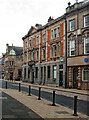
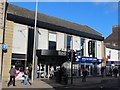
The western end of Priestpopple
Shows the location of Image
The Lloyds Bank building (nearest the camera) is Grade II listed https://historicengland.org.uk/listing/the-list/list-entry/1204136?section=official-list-entry, as is the Barclays Bank building https://historicengland.org.uk/listing/the-list/list-entry/1042549?section=official-list-entry .
Image: © Mike Quinn
Taken: 5 Jan 2009
0.01 miles
6
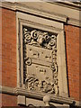
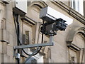
Ram's head and sheep stone panel, Priestpopple
There is another ram's head only a few yards away - see Image
Image: © Mike Quinn
Taken: 15 Feb 2010
0.01 miles
7
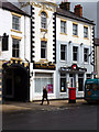
Hexham: The 'Royal Hotel'
On Priestpopple
Image: © Dr Neil Clifton
Taken: 11 May 2012
0.01 miles
8
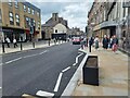
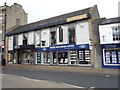
At long last!
The main traffic artery and shopping street in Hexham (B6305) is somewhat confusingly known under three names - Priestpopple at the eastern end, Battle Hill at the western end, and Cattle Market, a very short section between Broadgates and Eastgate in the middle. This view is taken from the north side of Priestpopple looking west towards Cattle Market.
Major works along these streets was undertaken from late 2023 to early 2024 under the guise of a street reconstruction scheme through the Hexham High Streets Heritage Action Zone (HSHAZ), part of a national £95 million government-funded programme, led by Historic England, designed to secure lasting improvements and rejuvenate historic high streets.
To facilitate the work, Battle Hill, Cattle Market and Priestpopple were reduced to one-way working west to east for the duration, causing considerable delays to east-west traffic.
At long last, the road works have been cleared away, traffic flows freely once more and we can appreciate the visual improvements brought about by the scheme.
It is somewhat unfortunate that the broad area of paving on the south side between the junctions with Broadgates and Commercial Place (on the far side of the street) was not part of the scheme, leaving a rather obvious contrast between the old and the new.
Image: © Oliver Dixon
Taken: 25 May 2024
0.01 miles
9
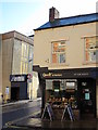
Donnies, Priestpopple
Originally Donnies, then Image, then Donnies again, although the large sign on the front still says "studio". Now temporarily (?) closed (November 2011).
Image: © Mike Quinn
Taken: 2 Nov 2011
0.02 miles