IMAGES TAKEN NEAR TO
Woodlands, HEXHAM, NE46 1HT
Introduction
This page details the photographs taken nearby to Woodlands, NE46 1HT by members of the Geograph project.
The Geograph project started in 2005 with the aim of publishing, organising and preserving representative images for every square kilometre of Great Britain, Ireland and the Isle of Man.

There are currently over 7.5m images from over14,400 individuals and you can help contribute to the project by visiting https://www.geograph.org.uk
Image Map
Images are licensed for reuse under creativecommons.org/licenses/by-sa/2.0
Notes
- Clicking on the map will re-center to the selected point.
- The higher the marker number, the further away the image location is from the centre of the postcode.
Image Listing (21 Images Found)
Images are licensed for reuse under creativecommons.org/licenses/by-sa/2.0
Image
Details
Distance
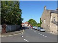
1
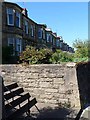
Woodlands
Imposing terrace of Victorian houses along the Corbridge Road (A695).
Image: © Oliver Dixon
Taken: 28 May 2012
0.02 miles
2
Service road behind Woodlands
Woodlands is a fine row of terraced houses along the Corbridge Road.
Image: © Oliver Dixon
Taken: 28 May 2012
0.02 miles
3
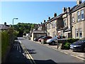
Monks Terrace
Older terraced houses just off the Corbridge Road. Beyond lie the steep wooded slopes on the south side of Tynedale.
Image: © Oliver Dixon
Taken: 28 May 2012
0.04 miles
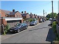
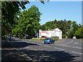
5
East end of Bywell Avenue
Suburban street in eastern Hexham.
Image: © Oliver Dixon
Taken: 28 May 2012
0.07 miles
6
Hudshaw Gardens
Leafy modern low-density suburban street behind Woodside.
Image: © Oliver Dixon
Taken: 28 May 2012
0.07 miles
7
Hillside Road
Leafy suburban road off the Corbridge Road at the east end of Hexham.
Image: © Oliver Dixon
Taken: 28 May 2012
0.07 miles
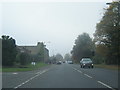
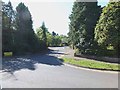
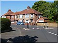
8
Junction of Dene Park and Peth Head
Dene Park (A695) is the main road into Hexham town centre from Corbridge. The turn to the right provides a short cut to the Wentworth Car Park and the Railway Station.
Image: © Oliver Dixon
Taken: 28 May 2012
0.07 miles
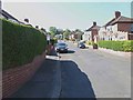
9
Traffic pinch-point on Bywell Avenue
Suburban street in eastern Hexham, with bay-fronted semi-detached houses. At least the traffic pinch point provides safe by-passes for cyclists (not all do).
Image: © Oliver Dixon
Taken: 28 May 2012
0.08 miles
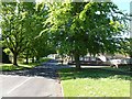
10
Langley Avenue
Suburban street on the east side of Hexham. Beyond lie the steep wooded slopes on the south side of Tynedale.
Image: © Oliver Dixon
Taken: 28 May 2012
0.12 miles