IMAGES TAKEN NEAR TO
Broomhaugh Close, HEXHAM, NE46 1DS
Introduction
This page details the photographs taken nearby to Broomhaugh Close, NE46 1DS by members of the Geograph project.
The Geograph project started in 2005 with the aim of publishing, organising and preserving representative images for every square kilometre of Great Britain, Ireland and the Isle of Man.

There are currently over 7.5m images from over14,400 individuals and you can help contribute to the project by visiting https://www.geograph.org.uk
Image Map
Images are licensed for reuse under creativecommons.org/licenses/by-sa/2.0
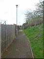
Notes
- Clicking on the map will re-center to the selected point.
- The higher the marker number, the further away the image location is from the centre of the postcode.
Image Listing (102 Images Found)
Images are licensed for reuse under creativecommons.org/licenses/by-sa/2.0
Image
Details
Distance
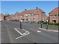
1
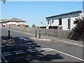
Traffic pinch point on Maiden's Walk
Traffic calming on a suburban street on the east side of Hexham. Acomb Court Care Home can be seen in the background.
Image: © Oliver Dixon
Taken: 28 May 2012
0.03 miles
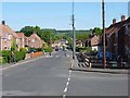
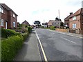
2
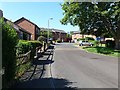
Residential close off Maiden's Walk, Hexham
Suburban street on the east side of Hexham. Beyond lie the steep wooded slopes on the south side of Tynedale.
Image: © Oliver Dixon
Taken: 28 May 2012
0.03 miles
3
Chirdon Crescent
Suburban street behind Hexham Hospital. Beyond lie the steep wooded slopes on the south side of Tynedale.
Image: © Oliver Dixon
Taken: 28 May 2012
0.05 miles
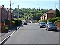
4
Springfield Road
Traffic-calmed suburban street in eastern Hexham. Beyond lie the steep wooded slopes on the south side of Tynedale.
Image: © Oliver Dixon
Taken: 28 May 2012
0.07 miles
5
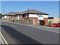
Acomb Court
A care home with nursing services on Maiden's Walk
Image: © Oliver Dixon
Taken: 28 May 2012
0.07 miles
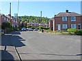
6
White Cross
Traffic-calmed suburban street in east Hexham running down to the Corbridge Road.
Image: © Oliver Dixon
Taken: 28 May 2012
0.10 miles
7
Traffic pinch point on Radcliffe Road
Suburban street in eastern Hexham. At least the traffic pinch point provides safe by-passes for cyclists (not all do).
Image: © Oliver Dixon
Taken: 28 May 2012
0.11 miles
8
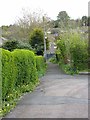
Path to Fellside
A steep public footpath climbs from the estate on Wanless Lane up to Fellside, off Gallows Bank. The lower section of this path is a formal tarmac path alongside the housing.
Image: © Oliver Dixon
Taken: 27 Apr 2012
0.12 miles
9
Path to Fellside
A steep public footpath climbs from the estate on Wanless Lane up to Fellside, off Gallows Bank. At this point, the public footpath forks right up the steep muddy bank. The level tarmac path flanks the top edge of the housing on Green Bank.
Image: © Oliver Dixon
Taken: 27 Apr 2012
0.13 miles
10
Allen Drive
Late twentieth century housing to the south-east of Hexham town centre.
Image: © Oliver Dixon
Taken: 27 Apr 2012
0.13 miles