IMAGES TAKEN NEAR TO
Street Houses, CORBRIDGE, NE45 5PF
Introduction
This page details the photographs taken nearby to Street Houses, NE45 5PF by members of the Geograph project.
The Geograph project started in 2005 with the aim of publishing, organising and preserving representative images for every square kilometre of Great Britain, Ireland and the Isle of Man.

There are currently over 7.5m images from over14,400 individuals and you can help contribute to the project by visiting https://www.geograph.org.uk
Image Map
Images are licensed for reuse under creativecommons.org/licenses/by-sa/2.0
Notes
- Clicking on the map will re-center to the selected point.
- The higher the marker number, the further away the image location is from the centre of the postcode.
Image Listing (8 Images Found)
Images are licensed for reuse under creativecommons.org/licenses/by-sa/2.0
Image
Details
Distance
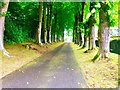
1
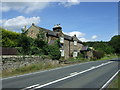
Cottages on Dere Street
The A68 follows the course of an Old Roman Road.
Image: © JThomas
Taken: 8 Aug 2015
0.00 miles
2
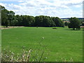
Grazing east of Dere Street Roman Road (A68)
Image: © JThomas
Taken: 8 Aug 2015
0.05 miles
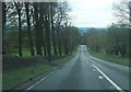
5
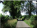
Minor road towards the A68
Heading south west.
Image: © JThomas
Taken: 8 Aug 2015
0.20 miles
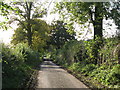
6
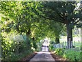
The lane to Chantry Farm
Photo taken from the southwest corner of NY9967.
Image: © Mike Quinn
Taken: 22 Oct 2008
0.23 miles
7
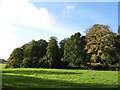
Woodland between Halton and Chantry Farm
Image: © Mike Quinn
Taken: 22 Oct 2008
0.25 miles