IMAGES TAKEN NEAR TO
Newcastle Road, CORBRIDGE, NE45 5LS
Introduction
This page details the photographs taken nearby to Newcastle Road, NE45 5LS by members of the Geograph project.
The Geograph project started in 2005 with the aim of publishing, organising and preserving representative images for every square kilometre of Great Britain, Ireland and the Isle of Man.

There are currently over 7.5m images from over14,400 individuals and you can help contribute to the project by visiting https://www.geograph.org.uk
Image Map
Images are licensed for reuse under creativecommons.org/licenses/by-sa/2.0
Notes
- Clicking on the map will re-center to the selected point.
- The higher the marker number, the further away the image location is from the centre of the postcode.
Image Listing (11 Images Found)
Images are licensed for reuse under creativecommons.org/licenses/by-sa/2.0
Image
Details
Distance
3
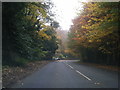
Western entrance to Howden Dene
Off the B6530.
Image: © Oliver Dixon
Taken: 24 Aug 2008
0.15 miles
5
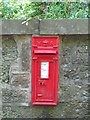
Victorian postbox near West Lodge, Howden Dene
This small 1881 wallbox has had the aperture modified to a width of 8 inches; the aperture was cut away and the new casting fitted in situ.
Image: © Mike Quinn
Taken: 9 Jun 2008
0.16 miles
6
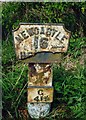
Old Milepost by the B6530, Howden Dene, Corbridge
Metal post with attached metal plate by the B6530, in parish of CORBRIDGE (TYNEDALE District), Howden Dene, near Cricket Plantation, on verge at junction with lane, on North side of road. Smith Patterson iron shield, erected by the Hexham turnpike trust in the 19th century.
Inscription reads:- : NEWCASTLE / 16 {arrow to right} / HE(XHAM / {arrow to left} 4½) : : C / 41¾ : : SMITH PATTERSON / & CO / BLAYDON :
Milestone Society National ID: NB_NCHX16.
Image: © IA Davison
Taken: 1 Oct 2002
0.16 miles
7
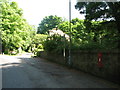
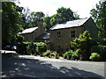
The west entrance to Howden Dene
Shows the location of Image
Image: © Mike Quinn
Taken: 9 Jun 2008
0.16 miles
8
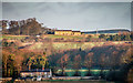
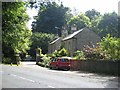
Croft Cottages
Croft Cottages (in the foreground) with Gallowhill (Image]) on the horizon.
Image: © Peter McDermott
Taken: 28 Dec 2011
0.17 miles
9
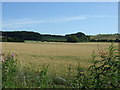
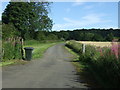
Crop field near Linn Burn House
Off the B6530.
Image: © JThomas
Taken: 8 Aug 2015
0.18 miles
10
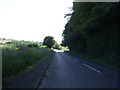
National Cycle Route 72
Heading east on the B6530.
Image: © JThomas
Taken: 8 Aug 2015
0.20 miles