IMAGES TAKEN NEAR TO
Hippingstones Lane, CORBRIDGE, NE45 5JP
Introduction
This page details the photographs taken nearby to Hippingstones Lane, NE45 5JP by members of the Geograph project.
The Geograph project started in 2005 with the aim of publishing, organising and preserving representative images for every square kilometre of Great Britain, Ireland and the Isle of Man.

There are currently over 7.5m images from over14,400 individuals and you can help contribute to the project by visiting https://www.geograph.org.uk
Image Map (Loading...)


Getting Data...Please wait
Leaflet Map data © OpenStreetMap
Images are licensed for reuse under creativecommons.org/licenses/by-sa/2.0
Notes
- Clicking on the map will re-center to the selected point.
- The higher the marker number, the further away the image location is from the centre of the postcode.
Image Listing (84 Images Found)
Images are licensed for reuse under creativecommons.org/licenses/by-sa/2.0
Image
Details
Distance
2
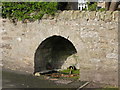
(Another) old water trough, Stagshaw Road
Image: © Mike Quinn
Taken: 19 Apr 2010
0.08 miles
3

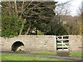
Path near Corbridge Middle School
Looking north.
Image: © JThomas
Taken: 8 Aug 2015
0.08 miles
4
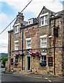
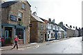
Corbridge : "The Wheatsheaf" public house
Image: © Jim Osley
Taken: 20 Jul 2022
0.09 miles
5
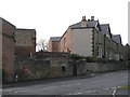
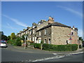
Houses on Stagshaw Road
Shows the location of Image
Image: © Mike Quinn
Taken: 19 Apr 2010
0.09 miles
6
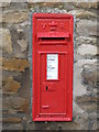
Victorian postbox, Stagshaw Lane / St. Helens Lane
Image: © Mike Quinn
Taken: 19 Apr 2010
0.09 miles
7
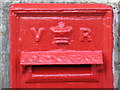
Victorian postbox, Stagshaw Lane / St. Helens Lane - royal cipher
See Image
Image: © Mike Quinn
Taken: 19 Apr 2010
0.09 miles
9
The Watling Coffee House and The Blue Bell on Hill Street
School crocodile about to cross.
Image: © Duncan Grey
Taken: 4 Jun 2008
0.10 miles