IMAGES TAKEN NEAR TO
Oaklands Rise, RIDING MILL, NE44 6EX
Introduction
This page details the photographs taken nearby to Oaklands Rise, NE44 6EX by members of the Geograph project.
The Geograph project started in 2005 with the aim of publishing, organising and preserving representative images for every square kilometre of Great Britain, Ireland and the Isle of Man.

There are currently over 7.5m images from over14,400 individuals and you can help contribute to the project by visiting https://www.geograph.org.uk
Image Map (Loading...)


Getting Data...Please wait
Leaflet Map data © OpenStreetMap
Images are licensed for reuse under creativecommons.org/licenses/by-sa/2.0
Notes
- Clicking on the map will re-center to the selected point.
- The higher the marker number, the further away the image location is from the centre of the postcode.
Image Listing (22 Images Found)
Images are licensed for reuse under creativecommons.org/licenses/by-sa/2.0
Image
Details
Distance
1
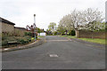
Oaklands Rise
An exclusive new housing development on the edge of Broomhaugh above Riding Mill.
Image: © Bill Boaden
Taken: 21 Apr 2017
0.02 miles
2
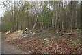
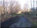
Evidence of woodland management
The woodland has been cut back to ensure that it does not encroach onto the track, but there isn't much evidence of actions taken deeper into the wood.
Image: © Bill Boaden
Taken: 21 Apr 2017
0.09 miles
3
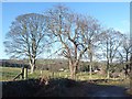
Wintry trees beside Whiteside Bank
Above the village of Broomhaugh.
Image: © Oliver Dixon
Taken: 9 Dec 2019
0.11 miles
5
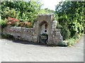
Old Drinking Trough, now a floral display
Image: © Bill Henderson
Taken: 18 Jun 2012
0.16 miles
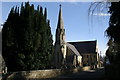
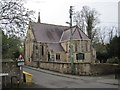
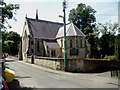
6
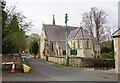
St James, Riding Mill
The village Anglican church. It looks very Victorian from the outside.
Image: © Bill Boaden
Taken: 21 Apr 2017
0.17 miles
9
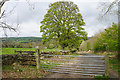
The old road to Broomley
This is the start of the old road to Broomley where it branches off from Whiteside Bank (the old A68). It is truncated 100 metres ahead by the cutting which carries the new A68, but continues on the same alignment on the far side of the main road. The old road now carries the status of bridleway but is diverted southwards for 300 metres to cross the new main road at High Shilford Farm.
Image: © Oliver Dixon
Taken: 9 Dec 2019
0.17 miles
10
Track down to Riding Mill
Incorporating a bridleway.
Image: © Bill Boaden
Taken: 21 Apr 2017
0.17 miles