IMAGES TAKEN NEAR TO
RIDING MILL, NE44 6DZ
Introduction
This page details the photographs taken nearby to NE44 6DZ by members of the Geograph project.
The Geograph project started in 2005 with the aim of publishing, organising and preserving representative images for every square kilometre of Great Britain, Ireland and the Isle of Man.

There are currently over 7.5m images from over14,400 individuals and you can help contribute to the project by visiting https://www.geograph.org.uk
Image Map
Images are licensed for reuse under creativecommons.org/licenses/by-sa/2.0
Notes
- Clicking on the map will re-center to the selected point.
- The higher the marker number, the further away the image location is from the centre of the postcode.
Image Listing (29 Images Found)
Images are licensed for reuse under creativecommons.org/licenses/by-sa/2.0
Image
Details
Distance
1
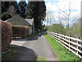
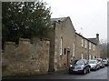
Underwood Road, Riding Mill
Taken from near the end of the road, Underwood Lodge is on the left and the railway line on the right.
Image: © Andrew Curtis
Taken: 26 Apr 2015
0.00 miles
2
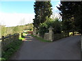
Underwood Road, Riding Mill
The drive to Wentworth Grange is on the right and the railway line on the left.
Image: © Andrew Curtis
Taken: 26 Apr 2015
0.01 miles
3
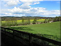
Pasture north-east of Wentworth Grange
The railway line is below the field with its bridge under the A68 visible on the extreme right.
Image: © Andrew Curtis
Taken: 26 Apr 2015
0.06 miles
4
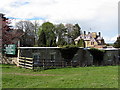
Wentworth Grange & Underwood Hall
Wentworth Grange is a Nursing and Residential Care Home. There is another photo here Image
Image: © Andrew Curtis
Taken: 26 Apr 2015
0.08 miles
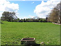
6
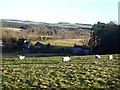
Field with sheep above Broomhaugh
Overlooking Tynedale. The woods on Sunny Bank can be seen on the far side of the Tyne.
Image: © Oliver Dixon
Taken: 9 Dec 2019
0.09 miles
7
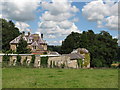
Wentworth Grange, Riding Mill
Now a residential care home for elderly people.
Image: © Mike Quinn
Taken: 9 Jul 2007
0.11 miles
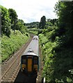
9
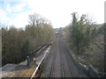
View from the station footbridge, Riding Mill looking east
The bridge immediately at the end of the platform crosses the Ridingmill Burn. The bridge in the distance carries the A695.
Image: © Jonathan Thacker
Taken: 30 Nov 2012
0.14 miles