IMAGES TAKEN NEAR TO
RIDING MILL, NE44 6BP
Introduction
This page details the photographs taken nearby to NE44 6BP by members of the Geograph project.
The Geograph project started in 2005 with the aim of publishing, organising and preserving representative images for every square kilometre of Great Britain, Ireland and the Isle of Man.

There are currently over 7.5m images from over14,400 individuals and you can help contribute to the project by visiting https://www.geograph.org.uk
Image Map
Images are licensed for reuse under creativecommons.org/licenses/by-sa/2.0
Notes
- Clicking on the map will re-center to the selected point.
- The higher the marker number, the further away the image location is from the centre of the postcode.
Image Listing (19 Images Found)
Images are licensed for reuse under creativecommons.org/licenses/by-sa/2.0
Image
Details
Distance
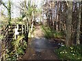
4
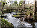
Footbridge and Ford on the edge of Todburn Wood
Image: © Clive Nicholson
Taken: 13 Nov 2009
0.04 miles
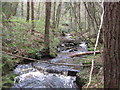
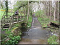
5
Ford on Reaston Burn
This ford is found along the Public Bridleway to Cleugh on the Reaston Burn.
http://youtu.be/PQrSsJC0LDs
Image: © John Walton
Taken: 3 May 2014
0.05 miles
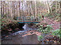
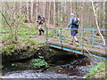
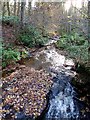
8
Ford and footbridge on the Reaston Burn
On a bridleway.
Image: © Oliver Dixon
Taken: 14 Nov 2012
0.06 miles
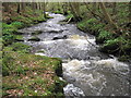
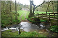
9
The Healey Burn
Looking upstream from the footbridge below Eastwood House
Image: © Oliver Dixon
Taken: 14 Nov 2012
0.07 miles