
IMAGES TAKEN NEAR TO
Healey, RIDING MILL, NE44 6BL
Introduction
This page details the photographs taken nearby to NE44 6BL by members of the Geograph project.
The Geograph project started in 2005 with the aim of publishing, organising and preserving representative images for every square kilometre of Great Britain, Ireland and the Isle of Man.

There are currently over 7.5m images from over14,400 individuals and you can help contribute to the project by visiting https://www.geograph.org.uk
Image Map
Images are licensed for reuse under creativecommons.org/licenses/by-sa/2.0
Notes
- Clicking on the map will re-center to the selected point.
- The higher the marker number, the further away the image location is from the centre of the postcode.
Image Listing (2 Images Found)
Images are licensed for reuse under creativecommons.org/licenses/by-sa/2.0
Image
Details
Distance
1

Minor road near Healey
Heading east towards the A68.
Image: © JThomas
Taken: 4 Jun 2016
0.22 miles
2
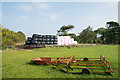
Bales, pink and black
Bales of silage are to be seen all over the British countryside. Generally the plastic sheeting used to package the silage has been black though other colours are seen; pink however is unusual. Perhaps there's a colour coding system in use.
North Sandyford and South Sandyford Plantations are in the distance beyond the bales.
Image: © Trevor Littlewood
Taken: 4 Oct 2015
0.24 miles