IMAGES TAKEN NEAR TO
Welton Close, STOCKSFIELD, NE43 7ER
Introduction
This page details the photographs taken nearby to Welton Close, NE43 7ER by members of the Geograph project.
The Geograph project started in 2005 with the aim of publishing, organising and preserving representative images for every square kilometre of Great Britain, Ireland and the Isle of Man.

There are currently over 7.5m images from over14,400 individuals and you can help contribute to the project by visiting https://www.geograph.org.uk
Image Map
Images are licensed for reuse under creativecommons.org/licenses/by-sa/2.0
Notes
- Clicking on the map will re-center to the selected point.
- The higher the marker number, the further away the image location is from the centre of the postcode.
Image Listing (4 Images Found)
Images are licensed for reuse under creativecommons.org/licenses/by-sa/2.0
Image
Details
Distance
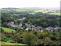
1

Path from New Ridley Road to High Mickley
Image: © Andrew Curtis
Taken: 12 Sep 2011
0.06 miles
2
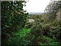
Overgrown path near Mickley Common
The footpath runs in a very straight line steeply uphill. It is possibly on the line of a former tramway connected with coal mining in the area but old maps do not support this.
Image: © Andrew Curtis
Taken: 12 Sep 2011
0.10 miles
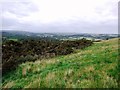
4
New Ridley Road, Painshawfield from Mickley Common
Image: © Andrew Curtis
Taken: 12 Sep 2011
0.20 miles