IMAGES TAKEN NEAR TO
Bywell, STOCKSFIELD, NE43 7AF
Introduction
This page details the photographs taken nearby to NE43 7AF by members of the Geograph project.
The Geograph project started in 2005 with the aim of publishing, organising and preserving representative images for every square kilometre of Great Britain, Ireland and the Isle of Man.

There are currently over 7.5m images from over14,400 individuals and you can help contribute to the project by visiting https://www.geograph.org.uk
Image Map
Images are licensed for reuse under creativecommons.org/licenses/by-sa/2.0
Notes
- Clicking on the map will re-center to the selected point.
- The higher the marker number, the further away the image location is from the centre of the postcode.
Image Listing (51 Images Found)
Images are licensed for reuse under creativecommons.org/licenses/by-sa/2.0
Image
Details
Distance
1
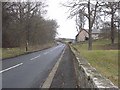
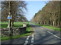
B6309 north of Bywell Bridge
Road from Stocksfield to Stamfordham.
Image: © Oliver Dixon
Taken: 26 Jan 2010
0.02 miles
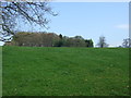
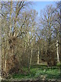
3
Trees in field corner
The field corner is at an angle of the B6309 at Bywell.
Image: © Trevor Littlewood
Taken: 11 Feb 2019
0.04 miles
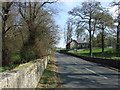
6
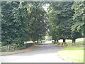
Road near Bywell
The B6309 at the north end of Bywell Bridge.
Image: © Paul Franks
Taken: 23 Sep 2012
0.08 miles
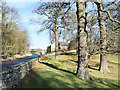
7
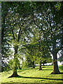
Trees near Bywell
Caught in evening sunshine.
Image: © Stephen Richards
Taken: Unknown
0.09 miles
8
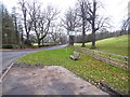
Road junction at the north end of Bywell Bridge
A number of benches have been installed in the vicinity. Same view in opposite direction of Image
Image: © Oliver Dixon
Taken: 24 Jan 2020
0.10 miles
9
National cycle route 72
Heading west, Bywell Park.
Image: © JThomas
Taken: 24 Apr 2015
0.10 miles