IMAGES TAKEN NEAR TO
Ovington, PRUDHOE, NE42 6YR
Introduction
This page details the photographs taken nearby to NE42 6YR by members of the Geograph project.
The Geograph project started in 2005 with the aim of publishing, organising and preserving representative images for every square kilometre of Great Britain, Ireland and the Isle of Man.

There are currently over 7.5m images from over14,400 individuals and you can help contribute to the project by visiting https://www.geograph.org.uk
Image Map (Loading...)


Getting Data...Please wait
Leaflet Map data © OpenStreetMap
Images are licensed for reuse under creativecommons.org/licenses/by-sa/2.0
Notes
- Clicking on the map will re-center to the selected point.
- The higher the marker number, the further away the image location is from the centre of the postcode.
Image Listing (21 Images Found)
Images are licensed for reuse under creativecommons.org/licenses/by-sa/2.0
Image
Details
Distance
1
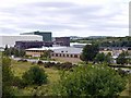
Low Prudhoe Industrial Estate, Princess Way
The industrial estate was formerly the site of the West Wylam Colliery and ICI Chemical Works. The latter was responsible for the Spetchells, hills of chalk dumped as industrial waste north of the railway line (visible behind, to the right). New industry has taken their place. Prudhoe Mill, a paper works and warehouse, operated by SCA Hygiene are on the left. In the centre is Thompsons of Prudhoe, demolition experts, currently removing Gateshead's 'Get Carter' car park.
Image: © Andrew Curtis
Taken: 29 Aug 2010
0.10 miles

3
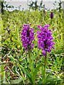
Northern Marsh Orchid (Dactylorhiza purpurella), The Spetchells
Image: © Andrew Curtis
Taken: 25 May 2022
0.18 miles
6
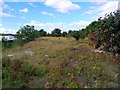
Woodland and track
Castlefields Wood West Wylam
Image: © peter maddison
Taken: 13 Dec 2010
0.20 miles
7

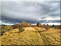
Climb to the Spetchells
Nearing the top of the Spetchells from the track that rises gradually from the north-east side.
Image: © Andrew Curtis
Taken: 27 Oct 2021
0.20 miles
8
Yellow-wort (Blackstonia perfoliata), The Spetchells
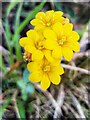
Yellow-wort is a yellow-flowered member of the Gentian family. It grows from ten to fifty centimetres tall with stiff, branching stems. The leaves are glaucous, opposite and entire, the upper ones perfoliate, being united at the base. It bears terminal cymes of bright yellow, stalked flowers, 1–1.5 cm across. The calyx is deeply divided into 6–10 linear lobes or sepals, spirally arranged, free or nearly free from each other at the base and shorter than the corolla. The petals number six to ten and form a short tube. There are six to ten adherent stamens and a two-lobed stigma. It flowers from June to October in Britain where it is widespread but not common.
https://en.wikipedia.org/wiki/Blackstonia_perfoliata
Its main habitats are lowland calcareous grasslands and fixed sand dunes, but it can be an abundant colonist of disturbed ground, including quarries and railway cuttings, and on road verges and pathsides.
There has been little change in the overall distribution of this species since the 1962 Atlas, although it has spread into Northumberland since then.
https://www.brc.ac.uk/plantatlas/plant/blackstonia-perfoliata
Image: © Andrew Curtis
Taken: 27 Oct 2021
0.21 miles
9

Hadrian's Cycleway, Tyne Riverside Park, Prudhoe
Ash and sycamore woodland planted on the steep northern slope of the Spetchells in order to stabilise the chalk, can be seen on the right.
Image: © Andrew Curtis
Taken: 29 Aug 2010
0.22 miles
10
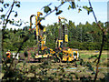
Engineering works on site of new Tyne View Retail Park
Aldi supermarket and KFC drive-thru set to open as part of new Prudhoe retail park, located just off the A695 Princess Way on the east side of Low Prudhoe
https://www.chroniclelive.co.uk/news/north-east-news/prudhoe-aldi-kfc-northumberland-shops-16864283
The restored agricultural land Image was previously an industrial part of West Wylam Colliery and Brick Works.
Image: © Andrew Curtis
Taken: 13 Sep 2019
0.22 miles