IMAGES TAKEN NEAR TO
Ovingham, PRUDHOE, NE42 6HJ
Introduction
This page details the photographs taken nearby to NE42 6HJ by members of the Geograph project.
The Geograph project started in 2005 with the aim of publishing, organising and preserving representative images for every square kilometre of Great Britain, Ireland and the Isle of Man.

There are currently over 7.5m images from over14,400 individuals and you can help contribute to the project by visiting https://www.geograph.org.uk
Image Map (Loading...)


Getting Data...Please wait
Leaflet Map data © OpenStreetMap
Images are licensed for reuse under creativecommons.org/licenses/by-sa/2.0
Notes
- Clicking on the map will re-center to the selected point.
- The higher the marker number, the further away the image location is from the centre of the postcode.
Image Listing (33 Images Found)
Images are licensed for reuse under creativecommons.org/licenses/by-sa/2.0
Image
Details
Distance
1
Road/bridleway between South Lodge and North Lodge
Image: © Roger Templeman
Taken: 14 Oct 2023
0.03 miles
2
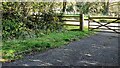
Gateway from sewage pumping station onto Ovingham to Wylam road
Ordnance Survey documents indicate that a rivet benchmark levelled at 13.426m above Newlyn Datum was verified in 1961 on a culvert at the junction of the stream on the left hand side of the track and the fence
Image: © Roger Templeman
Taken: 14 Oct 2023
0.10 miles
3
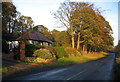
Tynewood
On the road between Ovingham and Wylam (heading east) on the north bank of the Tyne.
Image: © Alan Fearon
Taken: 21 Nov 2005
0.10 miles
4

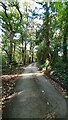
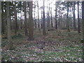
Footpath through woodland towards Horsley
Image: © Roger Templeman
Taken: 14 Oct 2023
0.15 miles

6

Public Footpath
Public Footpath in Horsley Wood Wylam
Image: © peter maddison
Taken: 2 Nov 2010
0.18 miles
8
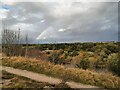
View over River Tyne from the Spetchells
A rainbow in the dark, sunlit sky shows of rain on its way.
Image: © Andrew Curtis
Taken: 27 Oct 2021
0.19 miles
9

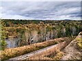
Summit of the Spetchells
A well-graded path leads up to the eastern end of the ridge of the Spetchells. Elsewhere, the precipitous slopes make access to the ridge very difficult. The old pumping station can be seen in the middle distance on the far side of the River Tyne.
Image: © Oliver Dixon
Taken: 23 Feb 2018
0.20 miles