IMAGES TAKEN NEAR TO
Ovington, PRUDHOE, NE42 6DN
Introduction
This page details the photographs taken nearby to NE42 6DN by members of the Geograph project.
The Geograph project started in 2005 with the aim of publishing, organising and preserving representative images for every square kilometre of Great Britain, Ireland and the Isle of Man.

There are currently over 7.5m images from over14,400 individuals and you can help contribute to the project by visiting https://www.geograph.org.uk
Image Map
Images are licensed for reuse under creativecommons.org/licenses/by-sa/2.0
Notes
- Clicking on the map will re-center to the selected point.
- The higher the marker number, the further away the image location is from the centre of the postcode.
Image Listing (27 Images Found)
Images are licensed for reuse under creativecommons.org/licenses/by-sa/2.0
Image
Details
Distance
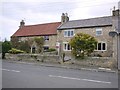
1
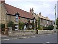
Leazes Cottage and Evenwood, Jubilee Road, Ovington
Image: © Andrew Curtis
Taken: 11 Oct 2013
0.02 miles
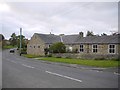
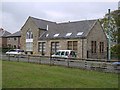
3
Modern housing, Ovington
Greenrising is a cul-de-sac of terraced housing built in 1960 by Hexham Rural
District Council, overlooking an open space fronting onto the main street.
Image: © Andrew Curtis
Taken: 11 Oct 2013
0.05 miles
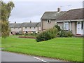
5
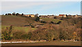
Ovington
The village of Ovington in Tyne Valley.
Image: © Peter McDermott
Taken: 11 Dec 2010
0.05 miles
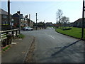
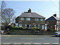
10
Ovington village
On a hill overlooking the floor of the Tyne valley.
Image: © Oliver Dixon
Taken: 13 Jan 2011
0.06 miles