IMAGES TAKEN NEAR TO
Bewick Lane, PRUDHOE, NE42 6BT
Introduction
This page details the photographs taken nearby to Bewick Lane, NE42 6BT by members of the Geograph project.
The Geograph project started in 2005 with the aim of publishing, organising and preserving representative images for every square kilometre of Great Britain, Ireland and the Isle of Man.

There are currently over 7.5m images from over14,400 individuals and you can help contribute to the project by visiting https://www.geograph.org.uk
Image Map (Loading...)


Getting Data...Please wait
Leaflet Map data © OpenStreetMap
Images are licensed for reuse under creativecommons.org/licenses/by-sa/2.0
Notes
- Clicking on the map will re-center to the selected point.
- The higher the marker number, the further away the image location is from the centre of the postcode.
Image Listing (150 Images Found)
Images are licensed for reuse under creativecommons.org/licenses/by-sa/2.0
Image
Details
Distance
3
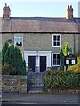
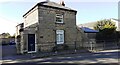
Ovingham Methodist Church
The church (3 Castle View) occupies part of a terrace and was founded in 1905.
There is a 1995 photo from the Stafford Linsley Collection here http://sine.ncl.ac.uk/view_image.asp?digital_doc_id=3121
Image: © Andrew Curtis
Taken: 7 Oct 2010
0.07 miles
4
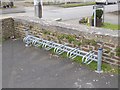
Cycle rack at the White Swan, Ovingham
One had rather hoped that this type of rack which barely supports the front wheel had been consigned to oblivion. But unfortunately not - here is a recent specimen installed outside the White Swan at Ovingham.
Image: © Oliver Dixon
Taken: 23 Feb 2018
0.07 miles
5
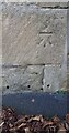
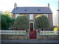
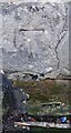
Benchmark on Bywell Cottage, west side of Horsley Road
Ordnance Survey cut mark benchmark levelled at 25.874m above Newlyn Datum in 1961 and verified 1964
Image: © Roger Templeman
Taken: 14 Oct 2023
0.07 miles
6
Bywell Cottage on west side of Horsley Road
There is an Ordnance Survey benchmark Image on the road face of the house at its right hand corner
Image: © Roger Templeman
Taken: 14 Oct 2023
0.07 miles
7
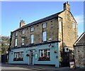
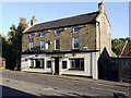
White Swan on SE side of Main Street
Image: © Roger Templeman
Taken: 14 Oct 2023
0.08 miles
8
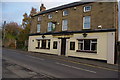
White Swan
White Swan Public House in Ovingham
Image: © peter maddison
Taken: 3 Nov 2010
0.08 miles
9
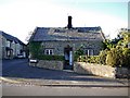
Benchmark on farm building on SE side of Main Road
Ordnance Survey cut mark benchmark levelled at 24.615m above Newlyn Datum in 1961 and verified 1964
Image: © Roger Templeman
Taken: 14 Oct 2023
0.08 miles