IMAGES TAKEN NEAR TO
Fern Close, PRUDHOE, NE42 5PL
Introduction
This page details the photographs taken nearby to Fern Close, NE42 5PL by members of the Geograph project.
The Geograph project started in 2005 with the aim of publishing, organising and preserving representative images for every square kilometre of Great Britain, Ireland and the Isle of Man.

There are currently over 7.5m images from over14,400 individuals and you can help contribute to the project by visiting https://www.geograph.org.uk
Image Map (Loading...)


Getting Data...Please wait
Leaflet Map data © OpenStreetMap
Images are licensed for reuse under creativecommons.org/licenses/by-sa/2.0
Notes
- Clicking on the map will re-center to the selected point.
- The higher the marker number, the further away the image location is from the centre of the postcode.
Image Listing (11 Images Found)
Images are licensed for reuse under creativecommons.org/licenses/by-sa/2.0
Image
Details
Distance
1
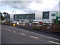
Ferndene, Prudhoe
Ferndene opened in autumn 2011 and is a purpose built £27 million inpatient centre which provides inpatient assessment and treatment for young people with complex health, behavioural and emotional needs, including those with a learning disability. Ferndene is the first such integrated service of its kind in the country. It was built on part of the former Prudhoe Hospital, off Moor Road, and continues the long history of health care on the site.
http://www.ntw.nhs.uk/sites.php?site=6
Image: © Andrew Curtis
Taken: 28 Apr 2012
0.04 miles
2
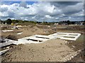
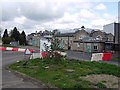
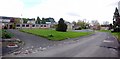
Humbles Wood development, Prudhoe
A new building site for housing development by the company, Gentoo, on part of the old Prudhoe Hospital site off Moor Road. Prudhoe Hall can be seen to the right.
Image: © Andrew Curtis
Taken: 28 Apr 2012
0.05 miles
3
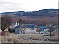
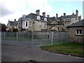
Prudhoe hospital
Previously the home of the mentally ill, this section of the hospital was closed some years ago for a multitude of reason. It is yet to be demolished and the lower section stays open as an old people's home.
Image: © Stefan Carlton
Taken: 8 Mar 2004
0.07 miles
5
Outbuildings south-west of Prudhoe Hall
Image: © Andrew Curtis
Taken: 28 Apr 2012
0.14 miles
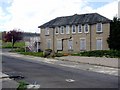
7
Prudhoe Hall
Part of the former Prudhoe Hospital for which the hall operated as an admnistration block. Formerly a country house built in 1878 for Matthew Liddle. It is a Grade II Listed Building http://list.english-heritage.org.uk/resultsingle.aspx?uid=1154615
The hall is now central to a development plan proposed for the former hospital estate of which 109 hectares are owned by the Homes and Communities Agency http://www.homesandcommunities.co.uk/news/community-help-shape-future-vision-prudhoe-hospital-site
Image: © Andrew Curtis
Taken: 28 Apr 2012
0.17 miles
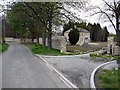
8
Disused road, former entrance to Prudhoe Hospital
Image: © Andrew Curtis
Taken: 28 Apr 2012
0.18 miles
9
Prudhoe Hospital
The former Activities Department building is on the left.
Image: © Andrew Curtis
Taken: 28 Apr 2012
0.20 miles
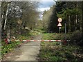
10
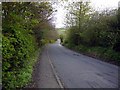
Moor Road, Prudhoe
Close to the site of the former Prudhoe Hospital.
Image: © Andrew Curtis
Taken: 28 Apr 2012
0.22 miles