IMAGES TAKEN NEAR TO
South Road, PRUDHOE, NE42 5LA
Introduction
This page details the photographs taken nearby to South Road, NE42 5LA by members of the Geograph project.
The Geograph project started in 2005 with the aim of publishing, organising and preserving representative images for every square kilometre of Great Britain, Ireland and the Isle of Man.

There are currently over 7.5m images from over14,400 individuals and you can help contribute to the project by visiting https://www.geograph.org.uk
Image Map
Images are licensed for reuse under creativecommons.org/licenses/by-sa/2.0
Notes
- Clicking on the map will re-center to the selected point.
- The higher the marker number, the further away the image location is from the centre of the postcode.
Image Listing (34 Images Found)
Images are licensed for reuse under creativecommons.org/licenses/by-sa/2.0
Image
Details
Distance
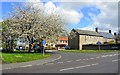
2
British Legion Houses, South Road, Prudhoe
Image: © Andrew Curtis
Taken: 12 Sep 2011
0.05 miles
4
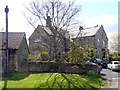
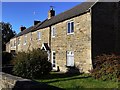
The Grange, Prudhoe
Prudhoe Grange is a private residence developed from a C13th chapel dedicated to St Thomas the Martyr, the oldest house in Prudhoe, and is said to be haunted. Bodies were found buried near the house in the 1950s thought to be of soldiers who died in the English Civil War. Disturbing events occurred when the owner carried out alterations in 1990 and were largely brought to an end after an exorcism and a requiem service.
http://www.thefreelibrary.com/Weird+tales.-a0138255135
There is another photo here Image
Image: © Andrew Curtis
Taken: 12 Sep 2011
0.08 miles
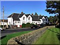
5
The Grange, South Road, Prudhoe
See description here Image
Image: © Andrew Curtis
Taken: 28 Apr 2012
0.08 miles
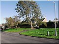
6
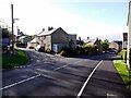
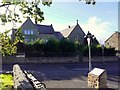
Junction of Highfield Lane and South Road, Prudhoe
The tower of Our Lady & St Cuthbert's Roman Catholic Church can be seen on the left Image It was originally built at Prudhoe Hall in 1891 but was moved and rebuilt here in 1904. St Matthew's Hall is on the left of the main road Image
Image: © Andrew Curtis
Taken: 12 Sep 2011
0.10 miles
7
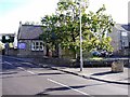
St Matthew's Hall, South Road, Prudhoe
The hall was built in the late C19th by local benefactors Matthew and Susanna Liddell as a free public reading room. There is another photo here Image The Liddell family were owners of collieries in the area and lived at Prudhoe Hall (now Prudhoe Hospital Image).
Image: © Andrew Curtis
Taken: 12 Sep 2011
0.12 miles
8
St Matthew's Hall from St Matthew's Lane, Prudhoe
Image: © Andrew Curtis
Taken: 12 Sep 2011
0.12 miles
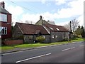
9
Terraced houses, South Road, Prudhoe
These houses were built after the previous thatched single-storey cottages known as St Thomas Terrace, after a nearby chapel, had burnt down.
Image: © Andrew Curtis
Taken: 12 Sep 2011
0.12 miles
10
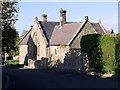
Former St Matthew's Roman Catholic School, St Matthew's Lane, Prudhoe
Built by local benefactors, the Liddells in the late C19th. The building now houses a Community Church, The Gate.
Image: © Andrew Curtis
Taken: 12 Sep 2011
0.15 miles