IMAGES TAKEN NEAR TO
Liddell Heights, NE42 5FY
Introduction
This page details the photographs taken nearby to Liddell Heights, NE42 5FY by members of the Geograph project.
The Geograph project started in 2005 with the aim of publishing, organising and preserving representative images for every square kilometre of Great Britain, Ireland and the Isle of Man.

There are currently over 7.5m images from over14,400 individuals and you can help contribute to the project by visiting https://www.geograph.org.uk
Image Map
Images are licensed for reuse under creativecommons.org/licenses/by-sa/2.0
Notes
- Clicking on the map will re-center to the selected point.
- The higher the marker number, the further away the image location is from the centre of the postcode.
Image Listing (19 Images Found)
Images are licensed for reuse under creativecommons.org/licenses/by-sa/2.0
Image
Details
Distance
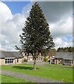
1
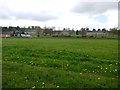
Former playing field, Prudhoe Hospital
Image: © Andrew Curtis
Taken: 28 Apr 2012
0.09 miles
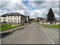
2
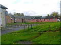
Disused buildings of Prudhoe Hospital
There is a photo from the same location here Image
Image: © Andrew Curtis
Taken: 28 Apr 2012
0.09 miles
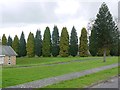
3
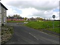
Disused buildings of Prudhoe Hospital
The former playing field area is on the right. This is from the same location Image
Image: © Andrew Curtis
Taken: 28 Apr 2012
0.10 miles
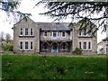

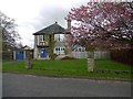
6
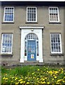
Disused building of Prudhoe Hospital
Main entrance to the former Skerne Department.
Image: © Andrew Curtis
Taken: 28 Apr 2012
0.12 miles