IMAGES TAKEN NEAR TO
North Wylam View, PRUDHOE, NE42 5FD
Introduction
This page details the photographs taken nearby to North Wylam View, NE42 5FD by members of the Geograph project.
The Geograph project started in 2005 with the aim of publishing, organising and preserving representative images for every square kilometre of Great Britain, Ireland and the Isle of Man.

There are currently over 7.5m images from over14,400 individuals and you can help contribute to the project by visiting https://www.geograph.org.uk
Image Map
Images are licensed for reuse under creativecommons.org/licenses/by-sa/2.0
Notes
- Clicking on the map will re-center to the selected point.
- The higher the marker number, the further away the image location is from the centre of the postcode.
Image Listing (11 Images Found)
Images are licensed for reuse under creativecommons.org/licenses/by-sa/2.0
Image
Details
Distance
1
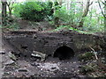
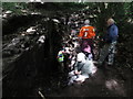
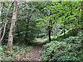
Industrial archaeology, Cockshot Dene, West Wylam
Entrance to a blocked level of West Wylam Colliery shown in process of archaeological excavation. A mechanical digger and some hard work revealed much more at the entrance Image
West Wylam Colliery was worked primarily from drifts and excavation suggests that this drift was used for ventilation with mounting of a large fan at the entrance.
The path (above left) leads to a brick and massive masonry built building which appears to have housed one of the colliery engines.
Image: © Andrew Curtis
Taken: 10 Sep 2019
0.14 miles
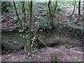
2
Industrial archaeology, Cockshot Dene, West Wylam
Image: © Andrew Curtis
Taken: 12 Sep 2019
0.14 miles
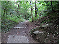
3
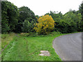
North entrance to Cockshot Dene
In the 1890s, the footpath to the right was the line of a cable-hauled railway which served the West Wylam Colliery. The bridleway which is just to the left Image and runs parallel to the former railway was a lane which provided access to the colliery, mainly situated behind the photographer. The road on the right is a more recent development providing a connection between West Wylam and the A695 Princess Way.
Image: © Andrew Curtis
Taken: 10 Sep 2019
0.14 miles
4
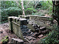
Industrial archaeology, Cockshot Dene, West Wylam
Uncovering a probable service level for West Wylam Colliery. An earlier stage of excavation is shown here Image
Image: © Andrew Curtis
Taken: 11 Sep 2019
0.14 miles
5
Industrial archaeology, Cockshot Dene, West Wylam
Culvert outlets at North end of Cockshot Dene.
Image: © Andrew Curtis
Taken: 10 Sep 2019
0.15 miles
6
Track at north end of Cockshot Dene
The top (south) end of the track is on Broomhouse Road.
Image: © Andrew Curtis
Taken: 10 Sep 2019
0.15 miles
7
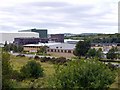
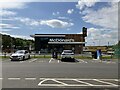
Low Prudhoe Industrial Estate, Princess Way
The industrial estate was formerly the site of the West Wylam Colliery and ICI Chemical Works. The latter was responsible for the Spetchells, hills of chalk dumped as industrial waste north of the railway line (visible behind, to the right). New industry has taken their place. Prudhoe Mill, a paper works and warehouse, operated by SCA Hygiene are on the left. In the centre is Thompsons of Prudhoe, demolition experts, currently removing Gateshead's 'Get Carter' car park.
Image: © Andrew Curtis
Taken: 29 Aug 2010
0.16 miles
9
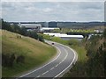
Low Prudhoe
The A695 runs through Prudhoe industrial estate, a stretch of road known as Princess Way.
Image: © Jane Burdis
Taken: 28 Apr 2006
0.23 miles