IMAGES TAKEN NEAR TO
West Wylam Drive, PRUDHOE, NE42 5ES
Introduction
This page details the photographs taken nearby to West Wylam Drive, NE42 5ES by members of the Geograph project.
The Geograph project started in 2005 with the aim of publishing, organising and preserving representative images for every square kilometre of Great Britain, Ireland and the Isle of Man.

There are currently over 7.5m images from over14,400 individuals and you can help contribute to the project by visiting https://www.geograph.org.uk
Image Map (Loading...)


Getting Data...Please wait
Leaflet Map data © OpenStreetMap
Images are licensed for reuse under creativecommons.org/licenses/by-sa/2.0
Notes
- Clicking on the map will re-center to the selected point.
- The higher the marker number, the further away the image location is from the centre of the postcode.
Image Listing (15 Images Found)
Images are licensed for reuse under creativecommons.org/licenses/by-sa/2.0
Image
Details
Distance
1
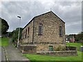
Ebenezer Methodist Chapel, West Wylam
Image: © Anthony Foster
Taken: 9 Oct 2023
0.09 miles
2
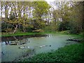
Pond, Priestclose Wood Nature Reserve
Priestclose Wood is an ancient woodland close to the centre of Prudhoe and contains varied deciduous woodland. Oak, birch and rowan are the most common species. The reserve is managed by the Northumberland Wildlife Trust. The wood is home to a variety of birds, including jay, treecreeper and redpoll; and the small pond to an assortment of amphibians.
http://www.nwt.org.uk/reserves/priestclose-wood
Image: © Andrew Curtis
Taken: 12 May 2012
0.17 miles
3

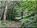
Stonyflat Bank near Prudhoe Waterworld
Image: © Andrew Curtis
Taken: 28 Apr 2012
0.17 miles
5
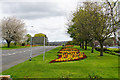
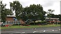
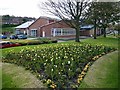
Floral display outside the leisure centre
Lining the main road at the eastern end of Prudhoe.
Image: © Bill Boaden
Taken: 18 Apr 2017
0.19 miles
9
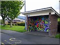
Decorated bus shelter, Stonyflat Bank, Prudhoe
The bus shelter is on the roadside, close to the Prudhoe Waterworld Leisure Pool.
Image: © Andrew Curtis
Taken: 28 Apr 2012
0.22 miles
10

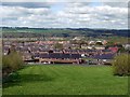
West Wylam from Prudhoe
View towards Wylam on the north bank of the River Tyne. Heddon on the Wall is the village behind, on the hilltop.
Image: © Andrew Curtis
Taken: 28 Apr 2012
0.22 miles