IMAGES TAKEN NEAR TO
Thomas Close, WYLAM, NE41 8BN
Introduction
This page details the photographs taken nearby to Thomas Close, NE41 8BN by members of the Geograph project.
The Geograph project started in 2005 with the aim of publishing, organising and preserving representative images for every square kilometre of Great Britain, Ireland and the Isle of Man.

There are currently over 7.5m images from over14,400 individuals and you can help contribute to the project by visiting https://www.geograph.org.uk
Image Map
Images are licensed for reuse under creativecommons.org/licenses/by-sa/2.0
Notes
- Clicking on the map will re-center to the selected point.
- The higher the marker number, the further away the image location is from the centre of the postcode.
Image Listing (61 Images Found)
Images are licensed for reuse under creativecommons.org/licenses/by-sa/2.0
Image
Details
Distance
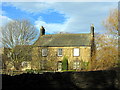
1
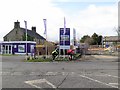
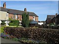
Housing development at Wylam Hills Farm
Wylam Hills Farm on Holeyn Hall Road has been derelict for at least 10 years and was a significant blot on the landscape at the northern side of Wylam village Image
The Sunderland-based developer Gentoo is now building 37 homes on two parcels of land, on either side of Holeyn Hall Road. West of the road, 25 luxury, four and five bedroomed houses are to be built and existing farm buildings demolished, with the stone-built stable block and farmhouse Image converted into dwellings. 11 affordable homes are being built on a smaller plot to the east of the road. The development has been named, Hedley Meadows.
Image: © Andrew Curtis
Taken: 19 Feb 2017
0.02 miles
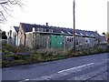
2
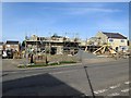
Construction of Hedley Meadows, Holeyn Hall Road, Wylam
Image: © Andrew Curtis
Taken: 27 Apr 2018
0.03 miles
4
Wylam Hills Farm from Church Road
See another photo here Image
Image: © Andrew Curtis
Taken: 25 Jan 2015
0.03 miles
5
Wylam Hills Farm
Partly derelict farm on the edge of the village Image
Image: © Andrew Curtis
Taken: 28 Dec 2011
0.03 miles
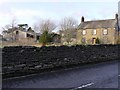
6
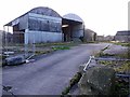
Wylam Hills Farm
Derelict farm site off Holeyn Hill Road on the edge of the village still awaiting development. The farm house and farm cottages apeear to be still in use.
Image: © Andrew Curtis
Taken: 28 Dec 2011
0.04 miles
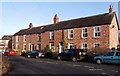
8
Rear of Dene Terrace West
The front of the terrace is shown here Image Dene Terrace East is on the right, served by a narrow lane.
Image: © Andrew Curtis
Taken: 27 Apr 2018
0.07 miles
9
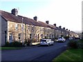
Algernon Terrace, Wylam
Algernon seems to have been a common name in these parts. The son of Charles Algernon Parsons, inventor of the steam turbine was Algernon George Parsons (b. 1886). He was killed in action during World War I in 1918, aged 31. Algernon was also a common family name of the Percy family, Dukes of Northumberland. Edward Algernon Blackett was the grandson of Christopher Blackett (1751-1829) owner of Wylam Colliery and major figure in development of the steam locomotive.
Image: © Andrew Curtis
Taken: 28 Dec 2011
0.10 miles