IMAGES TAKEN NEAR TO
George Street, RYTON, NE40 4DQ
Introduction
This page details the photographs taken nearby to George Street, NE40 4DQ by members of the Geograph project.
The Geograph project started in 2005 with the aim of publishing, organising and preserving representative images for every square kilometre of Great Britain, Ireland and the Isle of Man.

There are currently over 7.5m images from over14,400 individuals and you can help contribute to the project by visiting https://www.geograph.org.uk
Image Map (Loading...)


Getting Data...Please wait
Leaflet Map data © OpenStreetMap
Images are licensed for reuse under creativecommons.org/licenses/by-sa/2.0
Notes
- Clicking on the map will re-center to the selected point.
- The higher the marker number, the further away the image location is from the centre of the postcode.
Image Listing (13 Images Found)
Images are licensed for reuse under creativecommons.org/licenses/by-sa/2.0
Image
Details
Distance
1
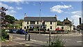
The Rising Sun
The Rising Sun is a converted and much extended 17th century stone cottage. It also sells some cracking real ale...
Image: © Steve McShane
Taken: 28 Jan 2006
0.08 miles
2
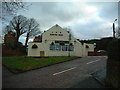
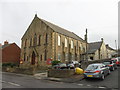
Centenary Methodist Church, Crawcrook
Image: © Bill Henderson
Taken: 20 Feb 2010
0.14 miles
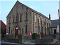
4
Centenary Methodist Church, Crawcrook
Image: © Anthony Foster
Taken: 7 Feb 2016
0.17 miles
8
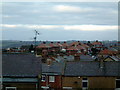
Over Crawcrook
A view of the top of Crawcrook, taken from Bank Top. Dare I say they'd get a good reception from up here...
Image: © Steve McShane
Taken: 28 Jan 2006
0.21 miles
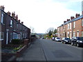
9
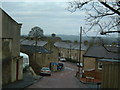
Bank Top / Main Street
A view down the hill towards what was formerly the main street through Crawcrook (the road is imaginatively called Old Main Street).
Image: © Steve McShane
Taken: 28 Jan 2006
0.21 miles