IMAGES TAKEN NEAR TO
Peth Lane, RYTON, NE40 3PD
Introduction
This page details the photographs taken nearby to Peth Lane, NE40 3PD by members of the Geograph project.
The Geograph project started in 2005 with the aim of publishing, organising and preserving representative images for every square kilometre of Great Britain, Ireland and the Isle of Man.

There are currently over 7.5m images from over14,400 individuals and you can help contribute to the project by visiting https://www.geograph.org.uk
Image Map (Loading...)


Getting Data...Please wait
Leaflet Map data © OpenStreetMap
Images are licensed for reuse under creativecommons.org/licenses/by-sa/2.0
Notes
- Clicking on the map will re-center to the selected point.
- The higher the marker number, the further away the image location is from the centre of the postcode.
Image Listing (16 Images Found)
Images are licensed for reuse under creativecommons.org/licenses/by-sa/2.0
Image
Details
Distance
1
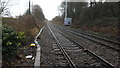
Newcastle and Carlisle Railway east of Peth Lane
Image: © Anthony Foster
Taken: 1 Jan 2018
0.04 miles
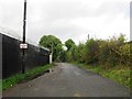
2
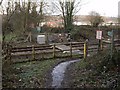
Level crossing, Peth Lane, Ryton
On 2 April 2009 a 17 year old man, Gino Shepherd, was tragically struck and killed by a train at this pedestrian crossing while listening to music through ear-phones. Flowers and cards for his 18th birthday in 2010 had been placed on the far gate.
http://www.chroniclelive.co.uk/north-east-news/evening-chronicle-news/2009/04/10/teen-killed-by-train-was-looking-forward-to-stag-do-72703-23360323/
The buildings at Whinhaven on the junction with Haugh Lane are visible behind.
Just south of the crossing, in the woods off Peth Lane there used to be a cottage known locally as Hoolet Hall or Howlet Hall. There is an old undated photo here http://isee.gateshead.gov.uk/detail.php?t=objects&type=all&f=&s=peth&record=2
Image: © Andrew Curtis
Taken: 3 Jan 2011
0.04 miles
3
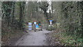
Approaching Peth Lane Crossing
The crossing is a pedestrian crossing of the Newcastle and Carlisle Railway near Ryton. The crossing is now controlled by lights presumably following a tragic accident outlined here Image
Image: © Anthony Foster
Taken: 1 Jan 2018
0.04 miles
4
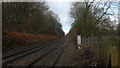
Newcastle and Carlisle Railway west of Peth Lane
Image: © Anthony Foster
Taken: 1 Jan 2018
0.05 miles
6
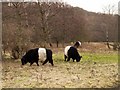
Belted Galloway cattle, Ryton Willows
The Grazing Advice Partnership http://www.grazinganimalsproject.org.uk/index which promotes conservation grazing describes the breed as a gentle animal with high aesthetic appeal, placid and unlikely to take any notice of walkers or dogs on a site. Their grazing is not particularly selective as they appear to take a wide range of grasses, shrubs and coarse herbs. One aim at Ryton Willows is the browsing of shrubs to counter their expansion and control rough vegetation to encourage finer grasses and wild flowers.
Image: © Andrew Curtis
Taken: 3 Jan 2011
0.11 miles
8
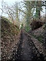
Peth Lane, Ryton
Peth Lane, also called Ryton Path, is probably an ancient route from Ryton Village down the steep bank to Newburn Ford on the north side of Holburn Dene.
It is possible that some of the English forces retreating from the Scots at the Battle of Newburn Ford (1640) Image may have used this route.
The landscape at that time is discussed in detail here http://www.english-heritage.org.uk/content/imported-docs/k-o/newburn.pdf
Image: © Andrew Curtis
Taken: 3 Jan 2011
0.17 miles
9
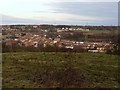
Field north of Peth Lane, Ryton
View north-east over the River Tyne towards Newburn and Walbottle.
Image: © Andrew Curtis
Taken: 3 Jan 2011
0.18 miles
10
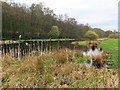
Gut Pond, Ryton Willows
There is another photo here Image
Image: © Andrew Curtis
Taken: 15 Apr 2016
0.20 miles