IMAGES TAKEN NEAR TO
The Hollies, King Edward Road, RYTON, NE40 3EL
Introduction
This page details the photographs taken nearby to The Hollies, King Edward Road, NE40 3EL by members of the Geograph project.
The Geograph project started in 2005 with the aim of publishing, organising and preserving representative images for every square kilometre of Great Britain, Ireland and the Isle of Man.

There are currently over 7.5m images from over14,400 individuals and you can help contribute to the project by visiting https://www.geograph.org.uk
Image Map
Images are licensed for reuse under creativecommons.org/licenses/by-sa/2.0
Notes
- Clicking on the map will re-center to the selected point.
- The higher the marker number, the further away the image location is from the centre of the postcode.
Image Listing (18 Images Found)
Images are licensed for reuse under creativecommons.org/licenses/by-sa/2.0
Image
Details
Distance
1
Former retired mineworkers cottages
On Stargate Lane.
Image: © Oliver Dixon
Taken: 23 Sep 2016
0.03 miles
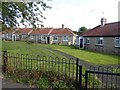
2
Coronation Street, Crookhill
Terrace of neat pale brick houses built by the Stella Coal Company as housing for employees at the Stargate and Addison pits.
Image: © Andrew Curtis
Taken: 24 Feb 2012
0.04 miles
3
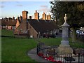
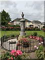
War memorial, Stargate Lane, Crookhill
The memorial was erected on 14th February 1920 to perpetuate the memory of the eleven men from the village of Stargate who fell in the Great War. Standing on a site at the northern entrance to the village, and abutting the main road way, the memorial takes the form of a circular monument in polished Aberdeen granite, with a base of Spanish freestone, and bears the inscription in imperishable lead writing: “Erected by the Stargate Welcome Home Association to the memory of the heroes whose names are recorded below, who served their country and sealed their love by death in the Great War. August 1914 - November1918. May their reward be as great as their sacrifices.”
A further 21 names were added to the memorial after the Second World War.
The memorial is described here http://www.rytonwarmemorials.org.uk/sub_memorial_section.php?page=stargate_war_memorial
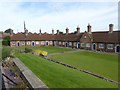
Behind are the Aged Miner's Homes on Stargate Lane, built in 1925.
Image: © Andrew Curtis
Taken: 24 Feb 2012
0.05 miles
5
Former mineworkers' cottages
On Stargate Lane.
Image: © Oliver Dixon
Taken: 23 Sep 2016
0.06 miles
6
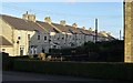
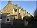
Simpson Street, Crookhill
A street of two rows of pale brick-built terraced houses with gardens fronting on a central path, road access being via narrow back lanes. The two end houses of the north side stand slightly in front of the other houses of the terrace. They were built by the Stella Coal Company to house their employees at Stargate and Addison pits. The Simpson family were majority shareholders in the Stella Coal Company.
Image: © Andrew Curtis
Taken: 24 Feb 2012
0.08 miles
7
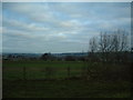
Recreation Ground
A place for games of football, and the locals to walk their dog(s)...
Image: © Steve McShane
Taken: 28 Jan 2006
0.10 miles
8
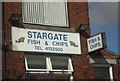
Stargate Fish & Chips
Stargate Fish & Chips near Ryton
Image: © Darren Haddock
Taken: 27 Aug 2006
0.11 miles
9
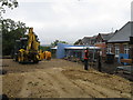
Alterations at Crookhill Primary School
Image: © Alex McGregor
Taken: 7 Sep 2010
0.11 miles
10
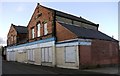
Former Co-operative Store, Hexham Old Road, Crookhill
This was originally a branch of the Blaydon Co-operative Society, built in 1901, opposite Crookhill Terrace and next door to the school.
Image: © Andrew Curtis
Taken: 24 Feb 2012
0.12 miles