IMAGES TAKEN NEAR TO
Holburn Lane, RYTON, NE40 3DF
Introduction
This page details the photographs taken nearby to Holburn Lane, NE40 3DF by members of the Geograph project.
The Geograph project started in 2005 with the aim of publishing, organising and preserving representative images for every square kilometre of Great Britain, Ireland and the Isle of Man.

There are currently over 7.5m images from over14,400 individuals and you can help contribute to the project by visiting https://www.geograph.org.uk
Image Map
Images are licensed for reuse under creativecommons.org/licenses/by-sa/2.0
Notes
- Clicking on the map will re-center to the selected point.
- The higher the marker number, the further away the image location is from the centre of the postcode.
Image Listing (12 Images Found)
Images are licensed for reuse under creativecommons.org/licenses/by-sa/2.0
Image
Details
Distance
1
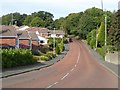
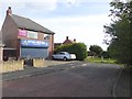
Holburn Lane
Residential road on the east side of Ryton.
Image: © Oliver Dixon
Taken: 23 Sep 2016
0.04 miles
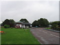
4
Peth Lane, Ryton
Peth Lane, also called Ryton Path, is probably an ancient route from Ryton Village down the steep bank to Newburn Ford on the north side of Holburn Dene.
It is possible that some of the English forces retreating from the Scots at the Battle of Newburn Ford (1640) Image may have used this route.
The landscape at that time is discussed in detail here http://www.english-heritage.org.uk/content/imported-docs/k-o/newburn.pdf
Image: © Andrew Curtis
Taken: 3 Jan 2011
0.16 miles
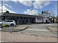
5
Ryton Fish Bar
Just off the main B6317.
Image: © Oliver Dixon
Taken: 23 Sep 2016
0.16 miles
6
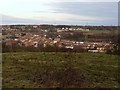
Field north of Peth Lane, Ryton
View north-east over the River Tyne towards Newburn and Walbottle.
Image: © Andrew Curtis
Taken: 3 Jan 2011
0.19 miles
7
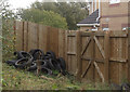
Hedgefield Woods
This is a nature area on the site of Addison colliery on the outskirts of Gateshead. It is a haven for foxes, roe deer, yellowhammers, used tyres and other woodland inhabitants. Here we are at the edge of the wood where it abuts new housing development with its attendant anti-social behaviour.
Image: © michael ely
Taken: 12 Oct 2008
0.20 miles
8

Part worn Pirellis
Dumped in Hedgefield Woods outside the back of a house. See http://www.geograph.org.uk/photo/1011097
Image: © michael ely
Taken: 12 Oct 2008
0.22 miles
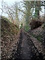
9
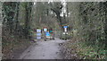
Approaching Peth Lane Crossing
The crossing is a pedestrian crossing of the Newcastle and Carlisle Railway near Ryton. The crossing is now controlled by lights presumably following a tragic accident outlined here Image
Image: © Anthony Foster
Taken: 1 Jan 2018
0.23 miles
10
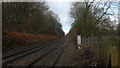
Newcastle and Carlisle Railway west of Peth Lane
Image: © Anthony Foster
Taken: 1 Jan 2018
0.23 miles