IMAGES TAKEN NEAR TO
Oakfield North, RYTON, NE40 3AD
Introduction
This page details the photographs taken nearby to Oakfield North, NE40 3AD by members of the Geograph project.
The Geograph project started in 2005 with the aim of publishing, organising and preserving representative images for every square kilometre of Great Britain, Ireland and the Isle of Man.

There are currently over 7.5m images from over14,400 individuals and you can help contribute to the project by visiting https://www.geograph.org.uk
Image Map
Images are licensed for reuse under creativecommons.org/licenses/by-sa/2.0
Notes
- Clicking on the map will re-center to the selected point.
- The higher the marker number, the further away the image location is from the centre of the postcode.
Image Listing (22 Images Found)
Images are licensed for reuse under creativecommons.org/licenses/by-sa/2.0
Image
Details
Distance
1
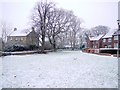
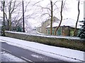
East Grange Farm, Barmoor Lane, Ryton
Looking across Barmoor Lane to the farmhouse of East Grange Farm from the green in front of the small new housing estate of Cypress Grove.
Image: © Andrew Curtis
Taken: 7 Jan 2011
0.10 miles
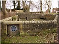
3
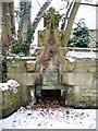
Causey Well, East Grange Farm, Ryton
See the description of a similar medieval water fountain on the boundary of the same property here Image The 1858 OS map shows 'Causeway Well' in this location. WA Cocks has it as 'Causey Well' probably a local name http://isee.gateshead.gov.uk/detail.php?t=objects&type=all&f=&s=ryton+well&record=0
There is a wider view of the location here Image
Image: © Andrew Curtis
Taken: 7 Jan 2011
0.11 miles
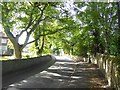
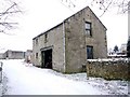
4
Farm buildings, East Grange Farm, Barmoor Lane, Ryton
Causey Well is at the end of the wall on the left Image
Image: © Andrew Curtis
Taken: 7 Jan 2011
0.13 miles
5
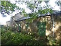
Old stables at East Grange Farm, Ryton
Image: © Oliver Dixon
Taken: 23 Sep 2016
0.13 miles

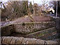
8
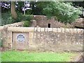
Ryton Village Pinfold
Originally used to hold stray cattle who were released on payment of a fine
Image: © ivan everett
Taken: 22 Jul 2007
0.16 miles
9
Ryton Pinfold, Barmoor Lane
The pinfold was built in the C12th as a pound for stray animals which were released on payment of a fine. The one here is unusual in that a source of water was supplied for the captive animals from a small stream entering below the wall and road at the north end Image
The pinfold was restored by Ryton Heritage Group in 1974.
There is an photo from c1900 here http://isee.gateshead.gov.uk/detail.php?t=objects&type=all&f=&s=ryton&record=156
See here for a similar view Image
Image: © Andrew Curtis
Taken: 3 Jan 2011
0.16 miles