IMAGES TAKEN NEAR TO
Keir Hardie Street, ROWLANDS GILL, NE39 2DF
Introduction
This page details the photographs taken nearby to Keir Hardie Street, NE39 2DF by members of the Geograph project.
The Geograph project started in 2005 with the aim of publishing, organising and preserving representative images for every square kilometre of Great Britain, Ireland and the Isle of Man.

There are currently over 7.5m images from over14,400 individuals and you can help contribute to the project by visiting https://www.geograph.org.uk
Image Map
Images are licensed for reuse under creativecommons.org/licenses/by-sa/2.0
Notes
- Clicking on the map will re-center to the selected point.
- The higher the marker number, the further away the image location is from the centre of the postcode.
Image Listing (7 Images Found)
Images are licensed for reuse under creativecommons.org/licenses/by-sa/2.0
Image
Details
Distance
1
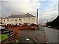
Engel's Street, Highfield
The name is a legacy from the days when this was still a mining village, with very left wing local authorities in the area.
Image: © Robert Graham
Taken: 12 Dec 2012
0.04 miles
2
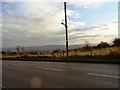
View south from Hookergate Lane
At Highfield, the western part of Rowlands Gill. Looking across the Derwent valley.
Image: © Robert Graham
Taken: 12 Dec 2012
0.10 miles
3
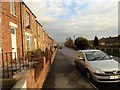
Hookergate Lane, Highfield
At the western end of Rowlands Gill is the former mining village of Highfield. The terrace on the left is South View.
Image: © Robert Graham
Taken: 12 Dec 2012
0.10 miles
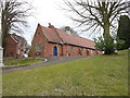
4
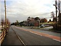
St Joseph's school
Catholic primary school at Highfield, at the western end of Rowlands Gill. View east down Hookergate Lane.
Image: © Robert Graham
Taken: 12 Dec 2012
0.11 miles
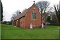
6
View of St Patrick's Church
This building sits right on a hilltop and is visible from miles around. It is particularly prominent from the Derwent Walk on the other side of the valley.
Image: © Robert Graham
Taken: 23 Feb 2012
0.23 miles
7
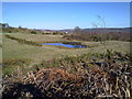
Pond at Beda Hills
With extensive views to the Tyne valley beyond.
Image: © Robert Graham
Taken: 18 Mar 2011
0.24 miles