IMAGES TAKEN NEAR TO
Sherburn Park Drive, ROWLANDS GILL, NE39 1QP
Introduction
This page details the photographs taken nearby to Sherburn Park Drive, NE39 1QP by members of the Geograph project.
The Geograph project started in 2005 with the aim of publishing, organising and preserving representative images for every square kilometre of Great Britain, Ireland and the Isle of Man.

There are currently over 7.5m images from over14,400 individuals and you can help contribute to the project by visiting https://www.geograph.org.uk
Image Map
Images are licensed for reuse under creativecommons.org/licenses/by-sa/2.0
Notes
- Clicking on the map will re-center to the selected point.
- The higher the marker number, the further away the image location is from the centre of the postcode.
Image Listing (16 Images Found)
Images are licensed for reuse under creativecommons.org/licenses/by-sa/2.0
Image
Details
Distance
1
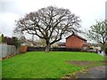
Grand tree in Dominies Close
So big, they kept a bit of open space round it, instead of squeezing in another house or two.
Image: © Christine Johnstone
Taken: 12 Apr 2012
0.07 miles
3
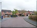
Bin day at Dominies Close
A convoluted layout, but named as all one road. Newish housing development off the A694, north of Rowlands Gill.
Image: © Christine Johnstone
Taken: 12 Apr 2012
0.07 miles
4
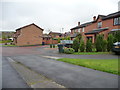
Room to turn in Dominies Close
Right angled stubs create space for a three-point turn at the end of this 'branch' of the road.
Image: © Christine Johnstone
Taken: 12 Apr 2012
0.07 miles
5
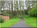
Footpath, Dominies Close estate
Linking one 'branch' of the road with the main section.
Image: © Christine Johnstone
Taken: 12 Apr 2012
0.09 miles
8
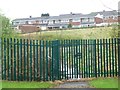
Houses in Sherburn Park Drive
Seen from Dominies Close. The locked gate used to give access to a school.
Image: © Christine Johnstone
Taken: 12 Apr 2012
0.12 miles
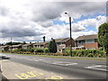
9
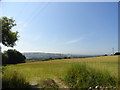
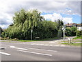
View south from beside Hollinside Lane
This lane rises steeply from the A694, the main road through Rowlands Gill, to give wide views of the south slopes of the Derwent valley.
Image: © Robert Graham
Taken: 25 Jul 2014
0.14 miles
10
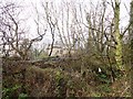
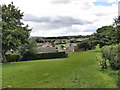
Old station at Rowlands Gill
Not much remains of the station here, on the former Derwent Valley Line. This is now the Derwent Walk footpath.
Image: © Robert Graham
Taken: 2 Jan 2013
0.14 miles