IMAGES TAKEN NEAR TO
Burnopfield Road, ROWLANDS GILL, NE39 1QH
Introduction
This page details the photographs taken nearby to Burnopfield Road, NE39 1QH by members of the Geograph project.
The Geograph project started in 2005 with the aim of publishing, organising and preserving representative images for every square kilometre of Great Britain, Ireland and the Isle of Man.

There are currently over 7.5m images from over14,400 individuals and you can help contribute to the project by visiting https://www.geograph.org.uk
Image Map
Images are licensed for reuse under creativecommons.org/licenses/by-sa/2.0
Notes
- Clicking on the map will re-center to the selected point.
- The higher the marker number, the further away the image location is from the centre of the postcode.
Image Listing (23 Images Found)
Images are licensed for reuse under creativecommons.org/licenses/by-sa/2.0
Image
Details
Distance
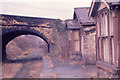
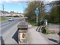
2
Route of former railway, Rowlands Gill
Now the Derwent Walk long distance footpath, this is the route of a railway from the Tyne valley to Consett.
Image: © Christine Johnstone
Taken: 26 Jan 2025
0.08 miles
3
Railway Cottages, Rowlands Gill
Built as homes for railway employees. There was not much more than a pub near here, before the railway line to Consett opened in 1867. Even by 1895 the large-scale OS maps shows only railway infrastructure here. To the right is the roof of the stationmaster's house.
Image: © Christine Johnstone
Taken: 26 Jan 2025
0.08 miles
5
Rowlands Gill - Derelict Railway Station
A picture of part of the old railway station at Rowlands Gill. Taken some time in the mid-late 1960's. Unfortunately exact date unknown. This part of the station now demolished, although the Station Master's house, the bridge and a part of the platform still remain.
http://www.disused-stations.org.uk/r/rowlands_gill/index.shtml
Image: © R J McNaughton
Taken: Unknown
0.12 miles
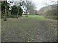
6
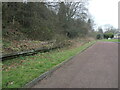
West-side platform edge, former Rowlands Gill station
Now the route of the Derwent Walk, but originally the line of a railway from Consett to the Tyne valley.
Image: © Christine Johnstone
Taken: 26 Jan 2025
0.13 miles
7
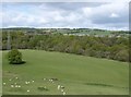
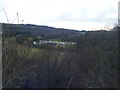
View West from a window in the ruined orangery, Gibside Hall
The grassy pasture of Warren's Haugh, the River Derwent almost unseen in the trees and the houses of Rowlands Gill beyond.
Image: © Derek Voller
Taken: 12 May 2015
0.14 miles
8
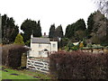
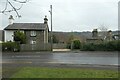
Cottage at Rowlands Gill
This attractive cottage, called The White Hills, is at the north end of Station Road.
Image: © Robert Graham
Taken: 2 Jan 2013
0.16 miles
9
Derwent Walk at Rowland's Gill
The Derwent Walk is a multi-user path for walkers, cyclists and horse-riders which follows the line of the old railway between Consett and the Tyne at Swalwell. It forms part of National Cycle Network route 14 which pursues a zigzag course across county Durham from Darlington to Hartlepool, Durham, Consett and Swalwell. It offers cyclists following the C2C an alternative route to finish at the sea at Tynemouth.
At this point the path, which runs alongside the main A694 for a short way through Rowland's Gill village diverges into a linear country park known as Derwent Walk Country Park and Derwenthaugh Country Park.
Image: © Oliver Dixon
Taken: 1 May 2013
0.19 miles
10
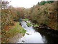
The River Derwent
This is the view of the river seen from the B6314 road bridge.
Image: © Bill Henderson
Taken: 15 Nov 2007
0.19 miles