IMAGES TAKEN NEAR TO
Stirling Lane, ROWLANDS GILL, NE39 1PR
Introduction
This page details the photographs taken nearby to Stirling Lane, NE39 1PR by members of the Geograph project.
The Geograph project started in 2005 with the aim of publishing, organising and preserving representative images for every square kilometre of Great Britain, Ireland and the Isle of Man.

There are currently over 7.5m images from over14,400 individuals and you can help contribute to the project by visiting https://www.geograph.org.uk
Image Map
Images are licensed for reuse under creativecommons.org/licenses/by-sa/2.0
Notes
- Clicking on the map will re-center to the selected point.
- The higher the marker number, the further away the image location is from the centre of the postcode.
Image Listing (42 Images Found)
Images are licensed for reuse under creativecommons.org/licenses/by-sa/2.0
Image
Details
Distance
1
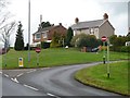
Houses on Stirling Lane, Rowlands Gill
Contrasting styles make them relatively easy to date.
Image: © Christine Johnstone
Taken: 12 Apr 2012
0.01 miles
2
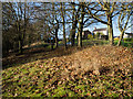
Bank above car park beside Derwent Walk
The roughly vegetated bank strewn with fallen leaves bounds the northern side of a car park convenient for walkers along the Derwent Walk. Stirling Lane lies beyond the bank.
Image: © Trevor Littlewood
Taken: 1 Jan 2017
0.05 miles
3
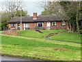
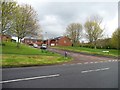
Bungalows on Stirling Lane, Rowlands Gill
Terraced bungalows are a distinctive feature in the former coalfields of County Durham and Tyne & Wear.
Image: © Christine Johnstone
Taken: 12 Apr 2012
0.06 miles
4
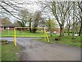
Car park entrance, Stirling Lane
Handy for walking the old railway line along the Derwent Valley, but caravnas and other larger vehicles are clearly discouraged.
Image: © Christine Johnstone
Taken: 12 Apr 2012
0.06 miles
5
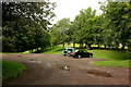
Car Park, Rowlands Gill
Car park adjacent to the former trackbed of the three valleys railway just off the B6314 at Rowlands Gill. The car park provides direct access to the western section of the Derwent Walk and cycleway.
Image: © Crispin Purdye
Taken: 21 Aug 2006
0.08 miles
6
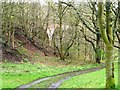
Track down to the riverbank
With a glimpse of the Derwent Valley railway viaduct through the trees.
Image: © Christine Johnstone
Taken: 12 Apr 2012
0.09 miles
7
Access road for houses on Burnopfield Road
More or less built on the line of the former Derwent Valley railway.
Image: © Christine Johnstone
Taken: 12 Apr 2012
0.09 miles
9
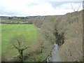
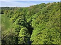
The River Derwent
Looking upstream from the former railway viaduct. The river is the boundary between County Durham (left) and Gateshead in Tyne & Wear (right).
Image: © Christine Johnstone
Taken: 12 Apr 2012
0.09 miles
10
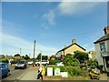
Station Road, Rowlands Gill
Looking east down the road, just in front of the bus stop.
Image: © Robert Graham
Taken: 6 Jun 2014
0.10 miles