IMAGES TAKEN NEAR TO
Hamsterley Mill, ROWLANDS GILL, NE39 1NG
Introduction
This page details the photographs taken nearby to NE39 1NG by members of the Geograph project.
The Geograph project started in 2005 with the aim of publishing, organising and preserving representative images for every square kilometre of Great Britain, Ireland and the Isle of Man.

There are currently over 7.5m images from over14,400 individuals and you can help contribute to the project by visiting https://www.geograph.org.uk
Image Map
Images are licensed for reuse under creativecommons.org/licenses/by-sa/2.0
Notes
- Clicking on the map will re-center to the selected point.
- The higher the marker number, the further away the image location is from the centre of the postcode.
Image Listing (16 Images Found)
Images are licensed for reuse under creativecommons.org/licenses/by-sa/2.0
Image
Details
Distance
1
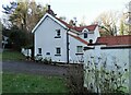
Longclose Gate Cottage
This house stands at the north end of Longclose Bank (the bottom of the bank). It's right beside the junction with the A694, the main road from Shotley Bridge to Swalwell and Tyneside. This is a former turnpike ,so this could have been a tollhouse , as it's marked as Longclose T P on the 1862 OS map.
Image: © Robert Graham
Taken: 6 Feb 2023
0.01 miles
2
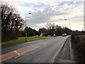
Road junction at Hamsterley Mill
Looking west along the A694 to the junction with the B6310 coming down from Medomsley and leading onto Burnopfield.
Image: © Robert Graham
Taken: 2 Jan 2013
0.03 miles
4
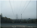
Power line at Hamsterley Mill
Pictured from the A694, the main road from Consett. This power line strides off up the valley side and through Chopwell Woods, which can be seen in the distance.
Image: © Robert Graham
Taken: 2 Jan 2013
0.09 miles
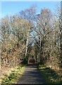
5
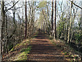
The Derwent Walk in Make-me-Rich Plantation
The Derwent Walk between Swalwell and Consett is also part of the National Cycle Network route 14.
Image: © Clive Nicholson
Taken: 19 Jan 2020
0.12 miles
6
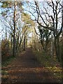
The Derwent Path passing through Make-me-rich Plantation
Image: © Oliver Dixon
Taken: 16 Dec 2021
0.12 miles
7
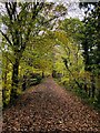
Autumn on the Derwent Walk path
The path / cycle route uses the former NER Derwent valley Branch
Image: © David Robinson
Taken: 1 Nov 2022
0.12 miles
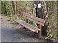
8
Memorial bench on the Derwent Path
Constructed in 1867 and running from Swalwell on the River Tyne up to Consett, the Derwent Valley railway finally closed in 1963. The footway on the line of the old railway has been converted into a cycleway and forms part of National Cycle Network route 14.
The bench commemorates Richard O'Connor, owner of the Golden Lion pub in Leadgate nearby. He was a keen cyclist and died of a heart attack at this spot on 16 October 2011. The spot is marked not only by the bench but by floral and poetic tributes.
The inscription on the bench reads:
In loving memory of Richard O'Connor
Aged 53
Died here 16-10-2011
"Where I fell is where I fly"
Image: © Oliver Dixon
Taken: 28 Feb 2014
0.12 miles
9
Memorial bench on the Derwent Path
Constructed in 1867 and running from Swalwell on the River Tyne up to Consett, the Derwent Valley railway finally closed in 1963. The footway on the line of the old railway has been converted into a cycleway and forms part of National Cycle Network route 14.
The bench commemorates Richard O'Connor, owner of the Golden Lion pub in Leadgate nearby. He was a keen cyclist and died of a heart attack at this spot on 16 October 2011. The spot is marked not only by the bench but by floral and poetic tributes.
The inscription on the bench reads:
In loving memory of Richard O'Connor
Aged 53
Died here 16-10-2011
"Where I fell is where I fly"
Image: © Oliver Dixon
Taken: 28 Feb 2014
0.13 miles
10
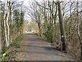
Dip in the Derwent Path
Missing bridges have resulted in a number of unwanted dips in the Derwent Path.
Image: © Oliver Dixon
Taken: 16 Dec 2021
0.15 miles